
Thank you for supporting this site ❤️
Make a donation
Make a donation
Gear up for your next adventure:
As an Amazon Associate, this site earns from qualifying purchases at no extra cost to you.
Montescheno topographic map
Click on the map to display elevation.
Thank you for supporting this site ❤️
Make a donation
Make a donation
Gear up for your next adventure:
As an Amazon Associate, this site earns from qualifying purchases at no extra cost to you.
About this map
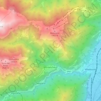
Name: Montescheno topographic map, elevation, terrain.
Location: Montescheno, Verbano-Cusio-Ossola, Piedmont, 28843, Italy (46.05398 8.14672 46.10225 8.23571)
Average elevation: 1,037 m
Minimum elevation: 223 m
Maximum elevation: 2,221 m
Thank you for supporting this site ❤️
Make a donation
Make a donation
Gear up for your next adventure:
As an Amazon Associate, this site earns from qualifying purchases at no extra cost to you.