
Make a donation
Gear up for your next adventure:
As an Amazon Associate, this site earns from qualifying purchases at no extra cost to you.
Switzerland topographic map
Click on the map to display elevation.
Make a donation
Gear up for your next adventure:
As an Amazon Associate, this site earns from qualifying purchases at no extra cost to you.
Switzerland
Switzerland’s topography is defined by a striking vertical and structural contrast across three main regions: the Alps, the Central Plateau (Mittelland), and the Jura Mountains. The Swiss Alps, covering about 60% of the country in the south and east, dominate the landscape with 48 peaks above 4,000 m, including the Dufourspitze at 4,634 m, and glaciated valleys shaped by ancient ice. In the northwest, the Jura Mountains form folded limestone ridges between roughly 800 m and 1,600 m, while the central Mittelland offers rolling hills, fertile plains, and large lakes at more moderate elevations of 400–700 m, where most of the population resides. The nation’s lowest point at Lake Maggiore (193 m) underscores the immense vertical range that influences climate, rivers like the Rhine and Rhône, and diverse land use, transitioning from permanent snow and jagged rock in the high Alps to pastoral meadows and deep lake basins in lower valleys.
Make a donation
Gear up for your next adventure:
As an Amazon Associate, this site earns from qualifying purchases at no extra cost to you.
About this map
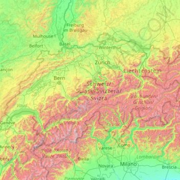
Name: Switzerland topographic map, elevation, terrain.
Location: Switzerland (45.81796 5.95591 47.80845 10.49229)
Average elevation: 1,016 m
Minimum elevation: 41 m
Maximum elevation: 4,564 m
Make a donation
Gear up for your next adventure:
As an Amazon Associate, this site earns from qualifying purchases at no extra cost to you.
Other topographic maps
Click on a map to view its topography, its elevation and its terrain.
Tbilisi
Most of the raions are named after historic quarters of the city. The citizens of Tbilisi widely recognise an informal system of smaller historic neighbourhoods. Such neighbourhoods are several, however, constituting a kind of hierarchy, because most of them have lost their distinctive topographic limits. The…
Average elevation: 713 m
Musandam
The rugged coastline resembles the glacier-carved coasts of polar regions, but in this case, the coast was shaped by the movement of Earth's crust. The Arabian Plate is slowly pushing under the Eurasian Plate, creating the earthquake-prone mountains of Iran. On the leading edge of the Arabian Plate, the…
Average elevation: 254 m
Make a donation
Gear up for your next adventure:
As an Amazon Associate, this site earns from qualifying purchases at no extra cost to you.
Make a donation
Gear up for your next adventure:
As an Amazon Associate, this site earns from qualifying purchases at no extra cost to you.
Europe
Europe's topography is characterized by a striking contrast between its rugged southern mountains and the expansive plains of the north. The continent is often described as a "peninsula of peninsulas," featuring major peninsulas like the Iberian, Italian, and Balkan, each with unique geological features. In…
Average elevation: 223 m
Make a donation
Gear up for your next adventure:
As an Amazon Associate, this site earns from qualifying purchases at no extra cost to you.
Make a donation
Gear up for your next adventure:
As an Amazon Associate, this site earns from qualifying purchases at no extra cost to you.
Great Skellig
The island is of special interest to archaeologists, as the monastic settlement is in unusually good condition. The monastery on the northern peak is situated at an elevation of 170 to 180 m (550 to 600 ft), Christ's Saddle at 129 m (422 ft), and the flagstaff area are 37 m (120 ft) above sea level. The…
Average elevation: 1 m
Make a donation
Gear up for your next adventure:
As an Amazon Associate, this site earns from qualifying purchases at no extra cost to you.
Lambay Island
Lambay Island is the largest island off the east coast of Ireland. It covers about 2.5 km2 (0.97 sq mi). The highest point – a hill known as Knockbane – rises to 126 m (413 ft). The island's high ground lies to the east and aside from Knockbane includes Heath Hill and Tinian Hill, and in the extreme…
Average elevation: 14 m
Make a donation
Gear up for your next adventure:
As an Amazon Associate, this site earns from qualifying purchases at no extra cost to you.
Make a donation
Gear up for your next adventure:
As an Amazon Associate, this site earns from qualifying purchases at no extra cost to you.
Make a donation
Gear up for your next adventure:
As an Amazon Associate, this site earns from qualifying purchases at no extra cost to you.
Make a donation
Gear up for your next adventure:
As an Amazon Associate, this site earns from qualifying purchases at no extra cost to you.
Make a donation
Gear up for your next adventure:
As an Amazon Associate, this site earns from qualifying purchases at no extra cost to you.
Lugnaquilla
Lugnaquilla is the 432nd-highest and 21st most prominent mountain in Britain and Ireland, on the Simms classification. It is regarded by the Scottish Mountaineering Club (SMC) as one of 34 Furths, which is a mountain above 3,000 ft (914 m) in elevation, and meets the other SMC criteria for a Munro (e.g.…
Average elevation: 696 m
Knocknapeasta
It is the 231st-highest mountain in Britain and Ireland on the Simm classification. Cnoc na Péiste is regarded by the Scottish Mountaineering Club ("SMC") as one of 34 Furths, which is a mountain above 3,000 ft (914.4 m) in elevation, and meets the other SMC criteria for a Munro (e.g. "sufficient…
Average elevation: 579 m
Make a donation
Gear up for your next adventure:
As an Amazon Associate, this site earns from qualifying purchases at no extra cost to you.
Caher
Caher is the 200th–highest mountain in Britain and Ireland on the Simm classification. Caher is regarded by the Scottish Mountaineering Club ("SMC") as one of 34 Furths, which is a mountain above 3,000 ft (914.4 m) in elevation, and meets the other SMC criteria for a Munro (e.g. "sufficient separation"), but…
Average elevation: 617 m
Beenkeragh
Beenkeragh is the second-highest peak in Ireland, on both the Arderin and Vandeleur-Lynam lists. It is the 179th-highest mountain in Britain and Ireland on the Simm classification. Beenkeragh is regarded by the Scottish Mountaineering Club ("SMC") as one of 34 Furths, which is a mountain above 3,000 ft (914 m)…
Average elevation: 654 m
Make a donation
Gear up for your next adventure:
As an Amazon Associate, this site earns from qualifying purchases at no extra cost to you.
Make a donation
Gear up for your next adventure:
As an Amazon Associate, this site earns from qualifying purchases at no extra cost to you.
Watergrasshill
According to A Topographical Dictionary of Ireland, published by Samuel Lewis in 1837, Watergrasshill then had a population of 533 people.
Average elevation: 164 m
Make a donation
Gear up for your next adventure:
As an Amazon Associate, this site earns from qualifying purchases at no extra cost to you.
Bloemfontein
South Africa > Free State > Mangaung Metropolitan Municipality
Situated at an elevation of 1,395 m (4,577 ft) above sea level, the city is home to 256,185 (as of 2011) residents and forms part of the Mangaung Metropolitan Municipality which has a population of 747,431. It was one of the host cities for the 2010 FIFA World Cup.
Average elevation: 1,374 m
Make a donation
Gear up for your next adventure:
As an Amazon Associate, this site earns from qualifying purchases at no extra cost to you.
Forest Park
United States > South Carolina > Charleston County > Charleston > Maryville
Average elevation: 5 m
Make a donation
Gear up for your next adventure:
As an Amazon Associate, this site earns from qualifying purchases at no extra cost to you.
Celtic Sea
The seabed under the Celtic Sea is referred to as the Celtic Shelf, part of the continental shelf of Europe. The northeast portion has a depth of between 90 and 100 m (300–330 ft), increasing towards Saint George's Channel. In the opposite direction, sand ridges pointing southwest have a similar height,…
Average elevation: 0 m
Foyle
United Kingdom > Northern Ireland > County Londonderry > Derry/Londonderry
Average elevation: 48 m
Make a donation
Gear up for your next adventure:
As an Amazon Associate, this site earns from qualifying purchases at no extra cost to you.
Tuzla
Bosnia and Herzegovina > Federation of Bosnia and Herzegovina > City of Tuzla
Average elevation: 349 m
Una
Bosnia and Herzegovina > Federation of Bosnia and Herzegovina > City of Bihać > Bihać
Average elevation: 255 m
Make a donation
Gear up for your next adventure:
As an Amazon Associate, this site earns from qualifying purchases at no extra cost to you.
Make a donation
Gear up for your next adventure:
As an Amazon Associate, this site earns from qualifying purchases at no extra cost to you.
Make a donation
Gear up for your next adventure:
As an Amazon Associate, this site earns from qualifying purchases at no extra cost to you.
Aguascalientes City
Mexico > Aguascalientes > Municipio de Aguascalientes
The Aguascalientes Bicentenary Velodrome, designed by Peter Junek, hosted the 2010 Pan American Track Championships. At an elevation of 1887m, the Velodrome is a frequent location for attempts at breaking the Cycling Hour Record.
Average elevation: 1,956 m
Make a donation
Gear up for your next adventure:
As an Amazon Associate, this site earns from qualifying purchases at no extra cost to you.
Make a donation
Gear up for your next adventure:
As an Amazon Associate, this site earns from qualifying purchases at no extra cost to you.
Prenton
Prenton is situated on the eastern side of the Wirral Peninsula, about 2.5 km (1.6 mi) west of the River Mersey at Tranmere Oil Terminal. The area is approximately 6.5 km (4 mi) south-south-east of the Irish Sea at Wallasey and about 7.5 km (5 mi) east-north-east of the Dee Estuary at Thurstaston. Prenton is…
Average elevation: 42 m
Make a donation
Gear up for your next adventure:
As an Amazon Associate, this site earns from qualifying purchases at no extra cost to you.
Hanle
Hanle is located in the valley of the Hanle River in the Changthang region of Ladakh. The river originates near Imis La [Wikidata] on the Indo-Tibetan border at 5,290 m (17,360 ft), and flows north, joining the Indus River at Loma, close to the town of Nyoma. After zig-zagging through mountain gorges for 60…
Average elevation: 4,287 m
Gallatin Gateway
United States > Montana > Gallatin County
Gallatin Gateway is a census-designated place (CDP) in Gallatin County, Montana, United States. As of the 2020 census, Gallatin Gateway had a population of 967. Elevation is 4,953 ft (1,510 m).
Average elevation: 1,519 m
Make a donation
Gear up for your next adventure:
As an Amazon Associate, this site earns from qualifying purchases at no extra cost to you.
Make a donation
Gear up for your next adventure:
As an Amazon Associate, this site earns from qualifying purchases at no extra cost to you.