
Thank you for supporting this site ❤️
Make a donation
Make a donation
Gear up for your next adventure:
As an Amazon Associate, this site earns from qualifying purchases at no extra cost to you.
Rouen topographic map
Click on the map to display elevation.
Thank you for supporting this site ❤️
Make a donation
Make a donation
Gear up for your next adventure:
As an Amazon Associate, this site earns from qualifying purchases at no extra cost to you.
About this map
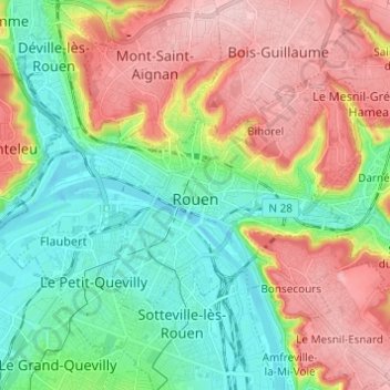
Name: Rouen topographic map, elevation, terrain.
Location: Rouen, Seine-Maritime, Normandy, Metropolitan France, France (49.41720 1.03006 49.46526 1.15212)
Average elevation: 72 m
Minimum elevation: -3 m
Maximum elevation: 171 m
Thank you for supporting this site ❤️
Make a donation
Make a donation
Gear up for your next adventure:
As an Amazon Associate, this site earns from qualifying purchases at no extra cost to you.
Other topographic maps
Click on a map to view its topography, its elevation and its terrain.
Le Tilleul - Antifer
France > Normandy > Seine-Maritime > La Poterie-Cap-d'Antifer
Average elevation: 42 m