
Dominica topographic map
Interactive map
Click on the map to display elevation.
Dominica
Dominica (locally /ˌdɒmɪˈniːkə/ dom-in-EE-kə; UK: US: /ˌdɒmɪˈniːkə/ or /dəˈmɪnɪkə/ ;) officially the Commonwealth of Dominica, is an island country in the Caribbean. The capital, Roseau, is the major port of the western side of the island. It is part of the Windward Islands chain in the Lesser Antilles archipelago of the Caribbean Sea. Dominica's closest neighbours are two constituent territories of the European Union, the overseas departments of France, Guadeloupe to the northwest and Martinique to the south-southeast. Dominica comprises a land area of 750 km2 (290 sq mi), and the highest point is Morne Diablotins, at 1,447 m (4,747 ft) in elevation. Its population was 71,293 at the 2011 census.
About this map
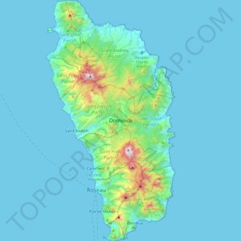
Name: Dominica topographic map, elevation, terrain.
Location: Dominica, Roseau, Saint Joseph Parish, Dominica (15.20763 -61.48012 15.64028 -61.24009)
Average elevation: 114 m
Minimum elevation: 0 m
Maximum elevation: 1,378 m