
The Glades topographic map
Interactive map
Click on the map to display elevation.
About this map
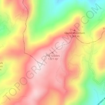
Name: The Glades topographic map, elevation, terrain.
Location: The Glades, Haywood County, North Carolina, United States (35.61728 -82.84269 35.61738 -82.84259)
Average elevation: 1,164 m
Minimum elevation: 889 m
Maximum elevation: 1,360 m
Other topographic maps
Click on a map to view its topography, its elevation and its terrain.
Waynesville
United States > North Carolina > Haywood County
Waynesville, Haywood County, North Carolina, 28786, United States
Average elevation: 921 m
Mount Lyn Lowry
United States > North Carolina > Haywood County
Mount Lyn Lowry, Haywood County, North Carolina, United States
Average elevation: 1,586 m
Little Bird Falls
United States > North Carolina > Haywood County
Little Bird Falls, Haywood County, North Carolina, United States
Average elevation: 1,347 m
Lake Junaluska
United States > North Carolina > Haywood County
Lake Junaluska, Haywood County, North Carolina, 28745, United States
Average elevation: 862 m
Lake Logan
United States > North Carolina > Haywood County > Sunburst
Lake Logan, Sunburst, Haywood County, North Carolina, United States
Average elevation: 1,061 m
Sugartree Licks
United States > North Carolina > Haywood County
Sugartree Licks, Haywood County, North Carolina, United States
Average elevation: 1,505 m
Hazelwood
United States > North Carolina > Haywood County > Waynesville
Hazelwood, Waynesville, Haywood County, North Carolina, 28786, United States
Average elevation: 888 m
Clyde
United States > North Carolina > Haywood County
Clyde, Haywood County, North Carolina, United States
Average elevation: 802 m
Maggie Valley
United States > North Carolina > Haywood County
Maggie Valley, Haywood County, North Carolina, United States
Average elevation: 1,247 m
Panther Creek
United States > North Carolina > Haywood County > Panther Creek
Panther Creek, Haywood County, North Carolina, United States
Average elevation: 873 m