
Make a donation
Gear up for your next adventure:
As an Amazon Associate, this site earns from qualifying purchases at no extra cost to you.
Linter topographic map
Click on the map to display elevation.
Make a donation
Gear up for your next adventure:
As an Amazon Associate, this site earns from qualifying purchases at no extra cost to you.
Linter
Linter liegt rund drei Kilometer südöstlich der Stadtmitte Limburgs an der B 417 (Hühnerstraße). Der alte Ortskern weist die typische, langgezogene Form eines Straßendorfs auf, obschon inzwischen vor allem im Nordwesten Neubaugebiete dazugekommen sind. Linter selbst liegt auf 180 Metern Höhe. Die Gemarkung ist weitgehend eben („Linterer Platte“ im Limburger Becken) und steigt nur nach Süden hin leicht auf bis zu 195 Meter an. Das kleine „Linterer Wäldchen“ am Nordrand des Ortes liegt auf Eschhofener Gemarkung. Die Linterer Gemarkung selbst besteht außerhalb der Bebauung fast ausschließlich aus landwirtschaftlich genutzter Fläche.
Make a donation
Gear up for your next adventure:
As an Amazon Associate, this site earns from qualifying purchases at no extra cost to you.
About this map
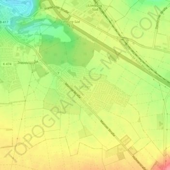
Name: Linter topographic map, elevation, terrain.
Average elevation: 183 m
Minimum elevation: 139 m
Maximum elevation: 219 m
Make a donation
Gear up for your next adventure:
As an Amazon Associate, this site earns from qualifying purchases at no extra cost to you.