
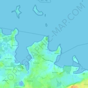
Le Ruault topographic map
Interactive map
Click on the map to display elevation.
About this map
Name: Le Ruault topographic map, elevation, terrain.
Average elevation: 3 m
Minimum elevation: -26 m
Maximum elevation: 31 m
Other topographic maps
Click on a map to view its topography, its elevation and its terrain.
Calzac-Bas
France > Bretagne > Morbihan > Sarzeau
Calzac-Bas, Sarzeau, Vannes, Morbihan, Bretagne, France métropolitaine, 56370, France
Average elevation: 14 m
Le Spernec
France > Bretagne > Morbihan > Sarzeau
Le Spernec, Sarzeau, Vannes, Morbihan, Bretagne, France métropolitaine, 56370, France
Average elevation: 20 m
La Corderie
France > Bretagne > Morbihan > Sarzeau > La Corderie
La Corderie, Sarzeau, Vannes, Morbihan, Bretagne, France métropolitaine, 56370, France
Average elevation: 18 m
Kermaillard
France > Bretagne > Morbihan > Sarzeau > Kermaillard
Kermaillard, Sarzeau, Vannes, Morbihan, Bretagne, France métropolitaine, 56370, France
Average elevation: 6 m
Kerstéphanie
France > Bretagne > Morbihan > Sarzeau
Kerstéphanie, Sarzeau, Vannes, Morbihan, Bretagne, France métropolitaine, 56370, France
Average elevation: 18 m