
Sofia-City topographic map
Interactive map
Click on the map to display elevation.
About this map
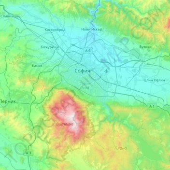
Name: Sofia-City topographic map, elevation, terrain.
Location: Sofia-City, Bulgaria (42.41237 23.05108 42.89656 23.67867)
Average elevation: 824 m
Minimum elevation: 501 m
Maximum elevation: 2,277 m
Other topographic maps
Click on a map to view its topography, its elevation and its terrain.
Pazardzhik
Bulgaria > Pazardzhik > Pazardzhik
Pazardzhik, Pazardzik, Pazardzhik, 4400, Bulgaria
Average elevation: 337 m
Golemo Buchino
Golemo Buchino, Pernik, 2304, Bulgaria
Average elevation: 837 m
Banski Suhodol Glacier
Banski Suhodol Glacier, За Гредаро, Kresna, Blagoevgrad, Bulgaria
Average elevation: 2,493 m