
Taggia topographic map
Interactive map
Click on the map to display elevation.
About this map
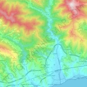
Name: Taggia topographic map, elevation, terrain.
Location: Taggia, Provincia di Imperia, Liguria, Italy (43.82834 7.79775 43.91399 7.88054)
Average elevation: 374 m
Minimum elevation: 0 m
Maximum elevation: 1,148 m
Other topographic maps
Click on a map to view its topography, its elevation and its terrain.
Triora
Italy > Liguria > Provincia di Imperia
Triora, Provincia di Imperia, Liguria, Italy
Average elevation: 1,149 m
Bussana
Italy > Liguria > Provincia di Imperia > Sanremo
Bussana, Sanremo, Provincia di Imperia, Liguria, 18011, Italy
Average elevation: 41 m