
Make a donation
Gear up for your next adventure:
As an Amazon Associate, this site earns from qualifying purchases at no extra cost to you.
Verosvres topographic map
Click on the map to display elevation.
Make a donation
Gear up for your next adventure:
As an Amazon Associate, this site earns from qualifying purchases at no extra cost to you.
About this map
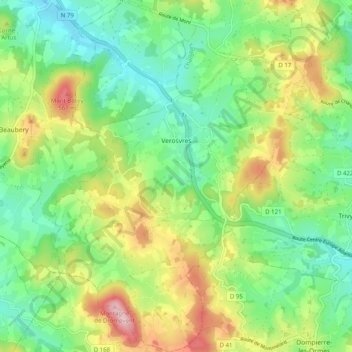
Name: Verosvres topographic map, elevation, terrain.
Average elevation: 418 m
Minimum elevation: 319 m
Maximum elevation: 598 m
Make a donation
Gear up for your next adventure:
As an Amazon Associate, this site earns from qualifying purchases at no extra cost to you.
Other topographic maps
Click on a map to view its topography, its elevation and its terrain.
Roche de Solutré
France > Bourgogne-Franche-Comté > Saône-et-Loire > Solutré-Pouilly > Solutré
Average elevation: 371 m
Saint-Pierre-de-Varennes
France > Bourgogne-Franche-Comté > Saône-et-Loire > Saint-Pierre-de-Varennes > Saint-Pierre-de-Varennes
Average elevation: 400 m
Make a donation
Gear up for your next adventure:
As an Amazon Associate, this site earns from qualifying purchases at no extra cost to you.
Les Longs Bois
France > Bourgogne-Franche-Comté > Saône-et-Loire > Saint-Forgeot
Average elevation: 305 m
Les Rues
France > Bourgogne-Franche-Comté > Saône-et-Loire > Fleury-la-Montagne
Average elevation: 376 m
Le Rousset
France > Bourgogne-Franche-Comté > Saône-et-Loire > Le Rousset-Marizy
Average elevation: 403 m
Make a donation
Gear up for your next adventure:
As an Amazon Associate, this site earns from qualifying purchases at no extra cost to you.
Make a donation
Gear up for your next adventure:
As an Amazon Associate, this site earns from qualifying purchases at no extra cost to you.
La Piat
France > Bourgogne-Franche-Comté > Saône-et-Loire > Saint-Amour-Bellevue
Average elevation: 243 m
Make a donation
Gear up for your next adventure:
As an Amazon Associate, this site earns from qualifying purchases at no extra cost to you.
Balme de Rochebin
France > Bourgogne-Franche-Comté > Saône-et-Loire > Azé > Montchanin
Average elevation: 305 m
Les Rompas
France > Bourgogne-Franche-Comté > Saône-et-Loire > Saint-Romain-sous-Gourdon
Average elevation: 361 m
Le Colombier
France > Bourgogne-Franche-Comté > Saône-et-Loire > Navour-sur-Grosne
Average elevation: 347 m
Make a donation
Gear up for your next adventure:
As an Amazon Associate, this site earns from qualifying purchases at no extra cost to you.
Les Vernes
France > Bourgogne-Franche-Comté > Saône-et-Loire > Saint-Bonnet-en-Bresse
Average elevation: 190 m
Les Crozes
France > Bourgogne-Franche-Comté > Saône-et-Loire > Saint-Igny-de-Roche
Average elevation: 421 m
Make a donation
Gear up for your next adventure:
As an Amazon Associate, this site earns from qualifying purchases at no extra cost to you.
Frêne
France > Bourgogne-Franche-Comté > Saône-et-Loire > Lournand > Sous Lourdon
Average elevation: 352 m
Make a donation
Gear up for your next adventure:
As an Amazon Associate, this site earns from qualifying purchases at no extra cost to you.
Make a donation
Gear up for your next adventure:
As an Amazon Associate, this site earns from qualifying purchases at no extra cost to you.
Martoret
France > Bourgogne-Franche-Comté > Saône-et-Loire > Saint-Maurice-de-Satonnay
Average elevation: 228 m
Commune
France > Bourgogne-Franche-Comté > Saône-et-Loire > Martigny-le-Comte
Average elevation: 353 m
Le Crot au Meunier
France > Bourgogne-Franche-Comté > Saône-et-Loire > La Grande-Verrière
Average elevation: 513 m
Make a donation
Gear up for your next adventure:
As an Amazon Associate, this site earns from qualifying purchases at no extra cost to you.
Arbain
France > Bourgogne-Franche-Comté > Saône-et-Loire > Savigny-sur-Seille
Average elevation: 191 m
Les Rochettes
France > Bourgogne-Franche-Comté > Saône-et-Loire > Chasselas > Les Rochettes
Average elevation: 386 m
Saint-Aubin-en-Charollais
France > Bourgogne-Franche-Comté > Saône-et-Loire > Saint-Aubin-en-Charollais > Saint-Aubin-en-Charollais
Average elevation: 282 m
Make a donation
Gear up for your next adventure:
As an Amazon Associate, this site earns from qualifying purchases at no extra cost to you.
Villemartin
France > Bourgogne-Franche-Comté > Saône-et-Loire > Saint-Julien-de-Civry
Average elevation: 333 m
Cruchaud
France > Bourgogne-Franche-Comté > Saône-et-Loire > Bissey-sous-Cruchaud
Average elevation: 347 m
Make a donation
Gear up for your next adventure:
As an Amazon Associate, this site earns from qualifying purchases at no extra cost to you.
Les Courtelets
France > Bourgogne-Franche-Comté > Saône-et-Loire > Montpont-en-Bresse
Average elevation: 197 m
Vellerot
France > Bourgogne-Franche-Comté > Saône-et-Loire > Saint-Bérain-sur-Dheune
Average elevation: 306 m
Make a donation
Gear up for your next adventure:
As an Amazon Associate, this site earns from qualifying purchases at no extra cost to you.
Château
France > Bourgogne-Franche-Comté > Saône-et-Loire > Berzé-le-Châtel > Les Baudys
Average elevation: 413 m
Make a donation
Gear up for your next adventure:
As an Amazon Associate, this site earns from qualifying purchases at no extra cost to you.
Bas de Vincelles
France > Bourgogne-Franche-Comté > Saône-et-Loire > Vincelles
Average elevation: 190 m
Make a donation
Gear up for your next adventure:
As an Amazon Associate, this site earns from qualifying purchases at no extra cost to you.
Make a donation
Gear up for your next adventure:
As an Amazon Associate, this site earns from qualifying purchases at no extra cost to you.
Le Bourg
France > Bourgogne-Franche-Comté > Saône-et-Loire > Saint-Gervais-en-Vallière
Average elevation: 200 m
Le Buet
France > Bourgogne-Franche-Comté > Saône-et-Loire > Saint-Léger-sous-Beuvray
Average elevation: 390 m
Le Paradis
France > Bourgogne-Franche-Comté > Saône-et-Loire > Saint-Martin-en-Bresse
Average elevation: 196 m
Make a donation
Gear up for your next adventure:
As an Amazon Associate, this site earns from qualifying purchases at no extra cost to you.
Polroy
France > Bourgogne-Franche-Comté > Saône-et-Loire > La Celle-en-Morvan
Average elevation: 342 m
Make a donation
Gear up for your next adventure:
As an Amazon Associate, this site earns from qualifying purchases at no extra cost to you.
Rougeon
France > Bourgogne-Franche-Comté > Saône-et-Loire > Bissey-sous-Cruchaud
Average elevation: 322 m
Borgy
France > Bourgogne-Franche-Comté > Saône-et-Loire > Dezize-lès-Maranges
Average elevation: 350 m
Make a donation
Gear up for your next adventure:
As an Amazon Associate, this site earns from qualifying purchases at no extra cost to you.
Saint-Léger
France > Bourgogne-Franche-Comté > Saône-et-Loire > Bourbon-Lancy
Average elevation: 261 m
Make a donation
Gear up for your next adventure:
As an Amazon Associate, this site earns from qualifying purchases at no extra cost to you.
La Baraque
France > Bourgogne-Franche-Comté > Saône-et-Loire > Saint-Martin-du-Mont
Average elevation: 192 m
La Rochelle
France > Bourgogne-Franche-Comté > Saône-et-Loire > La Chapelle-sous-Dun
Average elevation: 390 m
Make a donation
Gear up for your next adventure:
As an Amazon Associate, this site earns from qualifying purchases at no extra cost to you.
Les Moquets
France > Bourgogne-Franche-Comté > Saône-et-Loire > La Chapelle-sous-Dun
Average elevation: 387 m
Montagne des Boulets
France > Bourgogne-Franche-Comté > Saône-et-Loire > Le Creusot
Average elevation: 374 m
La Gare
France > Bourgogne-Franche-Comté > Saône-et-Loire > Romanèche-Thorins
Average elevation: 194 m
Make a donation
Gear up for your next adventure:
As an Amazon Associate, this site earns from qualifying purchases at no extra cost to you.
Foichot
France > Bourgogne-Franche-Comté > Saône-et-Loire > L'Abergement-Sainte-Colombe
Average elevation: 193 m
Forge
France > Bourgogne-Franche-Comté > Saône-et-Loire > Saint-Martin-d'Auxy
Average elevation: 357 m
Montailloux
France > Bourgogne-Franche-Comté > Saône-et-Loire > Saint-Laurent-en-Brionnais
Average elevation: 373 m
Make a donation
Gear up for your next adventure:
As an Amazon Associate, this site earns from qualifying purchases at no extra cost to you.
Vieil Moulin
France > Bourgogne-Franche-Comté > Saône-et-Loire > Sennecey-le-Grand
Average elevation: 206 m
Make a donation
Gear up for your next adventure:
As an Amazon Associate, this site earns from qualifying purchases at no extra cost to you.
Les Cours
France > Bourgogne-Franche-Comté > Saône-et-Loire > Fleury-la-Montagne
Average elevation: 381 m
Make a donation
Gear up for your next adventure:
As an Amazon Associate, this site earns from qualifying purchases at no extra cost to you.
Château de Brancion
France > Bourgogne-Franche-Comté > Saône-et-Loire > Martailly-lès-Brancion > Brancion
Average elevation: 325 m
Château de Brandon
France > Bourgogne-Franche-Comté > Saône-et-Loire > Saint-Pierre-de-Varennes
Average elevation: 420 m
Les Trois Croix
France > Bourgogne-Franche-Comté > Saône-et-Loire > Ligny-en-Brionnais
Average elevation: 394 m
Make a donation
Gear up for your next adventure:
As an Amazon Associate, this site earns from qualifying purchases at no extra cost to you.