Geolocate

Crete topographic map

Click on the map to display elevation.

About this map
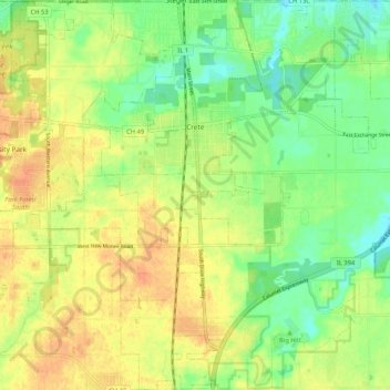
Name: Crete topographic map, elevation, terrain.

Location: Crete, Will County, Illinois, United States (41.39152 -87.67068 41.46999 -87.56946)

Average elevation: 224 m

Minimum elevation: 205 m

Maximum elevation: 241 m

Other topographic maps

Click on a map to view its topography, its elevation and its terrain.
Drummond

United States > Illinois > Will County

Average elevation: 167 m

Marley

United States > Illinois > Will County

Average elevation: 214 m

Puddle Pond

United States > Illinois > Will County > Plainfield

Average elevation: 187 m

Arbury Hills

United States > Illinois > Will County

Average elevation: 216 m

Gear up for your next adventure:

💳Travel Cards for Ireland - Convenient payment abroad
🎽Thermal Base Layers - Essential moisture management for cold weather
🥾Waterproof Hiking Boots - Best waterproof boots for wet Irish weather
💡Hiking Headlamps - Hands‑free lights for night hikes
🎒Technical Hiking Daypacks - Ergonomic backpacks with hydration bladder compatibility

As an Amazon Associate, this site earns from qualifying purchases at no extra cost to you.