
Make a donation
Gear up for your next adventure:
As an Amazon Associate, this site earns from qualifying purchases at no extra cost to you.
Williamstown topographic map
Click on the map to display elevation.
Make a donation
Gear up for your next adventure:
As an Amazon Associate, this site earns from qualifying purchases at no extra cost to you.
About this map
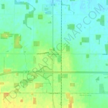
Name: Williamstown topographic map, elevation, terrain.
Location: Williamstown, Hancock County, Ohio, 45897, United States (40.81394 -83.67076 40.85394 -83.63076)
Average elevation: 283 m
Minimum elevation: 271 m
Maximum elevation: 300 m
Make a donation
Gear up for your next adventure:
As an Amazon Associate, this site earns from qualifying purchases at no extra cost to you.
Other topographic maps
Click on a map to view its topography, its elevation and its terrain.
Findlay
United States > Ohio > Hancock County
Findlay is situated on relatively flat terrain within the northwest region of the state, characterized by gently rolling hills and fertile plains. The city lies at an elevation of approximately 800 feet (244 meters) above sea level, with the Blanchard River meandering through the area, contributing to the…
Average elevation: 243 m