
Rizal topographic map
Interactive map
Click on the map to display elevation.
About this map
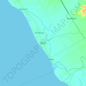
Name: Rizal topographic map, elevation, terrain.
Location: Rizal, Occidental Mindoro, Mimaropa, Philippines (12.41850 120.92388 12.49850 121.00388)
Average elevation: 4 m
Minimum elevation: -2 m
Maximum elevation: 45 m
Other topographic maps
Click on a map to view its topography, its elevation and its terrain.
Paluan
Philippines > Occidental Mindoro
The town is located at the north-western tip of Mindoro Island. It lies along the north-east shore of Paluan Bay, approximately 7 miles southeast of Cape Calavite, a major sea-lane for inter-island and ocean-going vessels. The town is surrounded by rolling and steep mountain ranges, of which Mount Calavite…
Average elevation: 111 m