
Make a donation
Gear up for your next adventure:
As an Amazon Associate, this site earns from qualifying purchases at no extra cost to you.
Volos Municipality topographic map
Click on the map to display elevation.
Make a donation
Gear up for your next adventure:
As an Amazon Associate, this site earns from qualifying purchases at no extra cost to you.
About this map
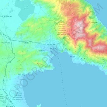
Name: Volos Municipality topographic map, elevation, terrain.
Average elevation: 228 m
Minimum elevation: -3 m
Maximum elevation: 1,604 m
Make a donation
Gear up for your next adventure:
As an Amazon Associate, this site earns from qualifying purchases at no extra cost to you.
Other topographic maps
Click on a map to view its topography, its elevation and its terrain.
Δημητριάδα
Greece > Thessaly and Central Greece > Regional Unit of Magnesia > Volos Municipality
Average elevation: 3 m
Pilion
Greece > Thessaly and Central Greece > Regional Unit of Magnesia > Municipal Unit of Mouresi
The mountain is thickly forested, with both deciduous and perennial forests, mainly of beech, oak, maple and chestnut trees, with olive, apple, pear trees and plane tree groves surrounding places with water. Pelion is considered one of the most beautiful mountains in Greece and is a popular tourist attraction…
Average elevation: 1,239 m
Σούρπη
Greece > Thessaly and Central Greece > Regional Unit of Magnesia > Municipal Unit of Sourpi
Average elevation: 123 m
Make a donation
Gear up for your next adventure:
As an Amazon Associate, this site earns from qualifying purchases at no extra cost to you.
Χάνια
Greece > Thessaly and Central Greece > Regional Unit of Magnesia > Volos Municipality
Average elevation: 1,103 m
Mouresi
Greece > Thessaly and Central Greece > Regional Unit of Magnesia > Municipal Unit of Mouresi
Average elevation: 303 m
Argalasti
Greece > Thessaly and Central Greece > Regional Unit of Magnesia > Municipal unit of Argalasti
Average elevation: 226 m
Kissos
Greece > Thessaly and Central Greece > Regional Unit of Magnesia > Municipal Unit of Mouresi
Average elevation: 482 m
Make a donation
Gear up for your next adventure:
As an Amazon Associate, this site earns from qualifying purchases at no extra cost to you.
Agios Ioannis
Greece > Thessaly and Central Greece > Regional Unit of Magnesia > Volos Municipality > Portaria
Average elevation: 815 m
Makrinitsa
Greece > Thessaly and Central Greece > Regional Unit of Magnesia > Volos Municipality
Average elevation: 663 m
Milina
Greece > Thessaly and Central Greece > Regional Unit of Magnesia > Sipias Municipal Unit
Average elevation: 81 m
Ano Volos
Greece > Thessaly and Central Greece > Regional Unit of Magnesia > Volos Municipality
Average elevation: 289 m
Make a donation
Gear up for your next adventure:
As an Amazon Associate, this site earns from qualifying purchases at no extra cost to you.