Geolocate

Bognor Regis topographic map

Click on the map to display elevation.

About this map

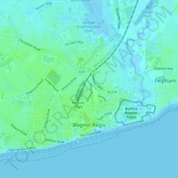
Name: Bognor Regis topographic map, elevation, terrain.

Location: Bognor Regis, Arun, West Sussex, England, United Kingdom (50.77779 -0.70068 50.80049 -0.65647)

Average elevation: 3 m

Minimum elevation: -2 m

Maximum elevation: 9 m

Other topographic maps

Click on a map to view its topography, its elevation and its terrain.

Bognor Regis

United Kingdom > England > West Sussex > Arun > Nyetimber

Average elevation: 2 m

Nyetimber

United Kingdom > England > West Sussex > Arun

Average elevation: 3 m

Lidsey Rife

United Kingdom > England > West Sussex > Arun > Felpham

Average elevation: 3 m

Elmer

United Kingdom > England > West Sussex > Arun

Average elevation: 2 m

Wick

United Kingdom > England > West Sussex > Arun > Littlehampton > Lyminster

Average elevation: 3 m

Shripney

United Kingdom > England > West Sussex > Arun

Average elevation: 3 m

Fontwell

United Kingdom > England > West Sussex > Arun

Average elevation: 31 m

Eastergate

United Kingdom > England > West Sussex > Arun

Average elevation: 12 m

North Bersted

United Kingdom > England > West Sussex > Arun

Average elevation: 3 m

Binsted

United Kingdom > England > West Sussex > Arun > Walberton

Average elevation: 23 m

Eastergate

United Kingdom > England > West Sussex > Arun

Average elevation: 12 m

Barnham

United Kingdom > England > West Sussex > Arun

Average elevation: 6 m

Gear up for your next adventure:

🖊️All-Weather Pens - Pressurized ink cartridges that write upside down and in wet
🛶Inflatable Touring Kayaks - Explore Irish loughs and coastal topography
🔨Multi-tool Devices - Versatile tools for gear repairs in the field
🌄Sun Protection Gear - Gear to shield from strong sun
🚨Emergency Whistles - Safety whistles for hikers

As an Amazon Associate, this site earns from qualifying purchases at no extra cost to you.