
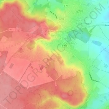
Montfort-l'Amaury topographic map
Interactive map
Click on the map to display elevation.
About this map
Name: Montfort-l'Amaury topographic map, elevation, terrain.
Average elevation: 152 m
Minimum elevation: 94 m
Maximum elevation: 189 m
Other topographic maps
Click on a map to view its topography, its elevation and its terrain.
Chatou
France > Ile-de-France > Yvelines
Chatou, Saint-Germain-en-Laye, Yvelines, Ile-de-France, Metropolitan France, 78400, France
Average elevation: 40 m
Rambouillet
France > Ile-de-France > Yvelines
Rambouillet, Yvelines, Ile-de-France, Metropolitan France, 78120, France
Average elevation: 166 m
Orgeval
France > Ile-de-France > Yvelines
Orgeval, Saint-Germain-en-Laye, Yvelines, Ile-de-France, Metropolitan France, 78630, France
Average elevation: 128 m
L'Étang-la-Ville
France > Ile-de-France > Yvelines
L'Étang-la-Ville, Saint-Germain-en-Laye, Yvelines, Ile-de-France, Metropolitan France, 78620, France
Average elevation: 136 m
La Verrière
France > Ile-de-France > Yvelines
La Verrière, Rambouillet, Yvelines, Ile-de-France, Metropolitan France, 78320, France
Average elevation: 172 m
Orgerus
France > Ile-de-France > Yvelines
Orgerus, Mantes-la-Jolie, Yvelines, Ile-de-France, Metropolitan France, 78910, France
Average elevation: 128 m
Buc
France > Ile-de-France > Yvelines
Buc, Versailles, Yvelines, Ile-de-France, Metropolitan France, 78530, France
Average elevation: 151 m
Grosrouvre
France > Ile-de-France > Yvelines
Grosrouvre, Rambouillet, Yvelines, Ile-de-France, Metropolitan France, 78490, France
Average elevation: 165 m
Garnes
France > Ile-de-France > Yvelines > Senlisse
Garnes, Senlisse, Rambouillet, Yvelines, Ile-de-France, Metropolitan France, 78720, France
Average elevation: 150 m
Trappes
France > Ile-de-France > Yvelines
Trappes, Versailles, Yvelines, Ile-de-France, Metropolitan France, 78190, France
Average elevation: 167 m
Dampierre-en-Yvelines
France > Ile-de-France > Yvelines
Dampierre-en-Yvelines, Rambouillet, Yvelines, Ile-de-France, Metropolitan France, 78720, France
Average elevation: 145 m
Le Mesnil-Saint-Denis
France > Ile-de-France > Yvelines
Le Mesnil-Saint-Denis, Rambouillet, Yvelines, Ile-de-France, Metropolitan France, 78320, France
Average elevation: 163 m
Gambais
France > Ile-de-France > Yvelines
Gambais, Rambouillet, Yvelines, Ile-de-France, Metropolitan France, 78950, France
Average elevation: 130 m
Châteaufort
France > Ile-de-France > Yvelines
Châteaufort, Versailles, Yvelines, Ile-de-France, Metropolitan France, 78117, France
Average elevation: 150 m
Rochefort-en-Yvelines
France > Ile-de-France > Yvelines
Rochefort-en-Yvelines, Rambouillet, Yvelines, Ile-de-France, Metropolitan France, 78730, France
Average elevation: 112 m
Saint-Rémy-lès-Chevreuse
France > Ile-de-France > Yvelines
Saint-Rémy-lès-Chevreuse, Rambouillet, Yvelines, Ile-de-France, Metropolitan France, 78470, France
Average elevation: 132 m
Conflans-Sainte-Honorine
France > Ile-de-France > Yvelines
Conflans-Sainte-Honorine, Saint-Germain-en-Laye, Yvelines, Ile-de-France, Metropolitan France, 78700, France
Average elevation: 43 m
Vélizy-Villacoublay
France > Ile-de-France > Yvelines
Vélizy-Villacoublay, Versailles, Yvelines, Ile-de-France, Metropolitan France, 78140, France
Average elevation: 154 m
Guyancourt
France > Ile-de-France > Yvelines > Guyancourt
Guyancourt, Versailles, Yvelines, Ile-de-France, Metropolitan France, 78280, France
Average elevation: 161 m
Chevreuse
France > Ile-de-France > Yvelines
Chevreuse, Rambouillet, Yvelines, Ile-de-France, Metropolitan France, 78460, France
Average elevation: 135 m
Limay
France > Ile-de-France > Yvelines
Limay, Mantes-la-Jolie, Yvelines, Ile-de-France, Metropolitan France, 78520, France
Average elevation: 57 m
Sartrouville
France > Ile-de-France > Yvelines
Sartrouville, Saint-Germain-en-Laye, Yvelines, Ile-de-France, Metropolitan France, 78500, France
Average elevation: 41 m
Plaisir
France > Ile-de-France > Yvelines
Plaisir, Versailles, Yvelines, Ile-de-France, Metropolitan France, 78370, France
Average elevation: 139 m
Maisons-Laffitte
France > Ile-de-France > Yvelines
Maisons-Laffitte, Saint-Germain-en-Laye, Yvelines, Ile-de-France, Metropolitan France, 78600, France
Average elevation: 39 m
Jouy-en-Josas
France > Ile-de-France > Yvelines
Jouy-en-Josas, Versailles, Yvelines, Ile-de-France, Metropolitan France, 78350, France
Average elevation: 148 m
Achères
France > Ile-de-France > Yvelines > Achères
Achères, Saint-Germain-en-Laye, Yvelines, Ile-de-France, Metropolitan France, 78260, France
Average elevation: 51 m
Meulan-en-Yvelines
France > Ile-de-France > Yvelines
Meulan-en-Yvelines, Mantes-la-Jolie, Yvelines, Ile-de-France, Metropolitan France, 78250, France
Average elevation: 49 m
Bouafle
France > Ile-de-France > Yvelines
Bouafle, Mantes-la-Jolie, Yvelines, Ile-de-France, Metropolitan France, 78410, France
Average elevation: 87 m
Aubergenville
France > Ile-de-France > Yvelines
Aubergenville, Mantes-la-Jolie, Yvelines, Ile-de-France, Metropolitan France, 78410, France
Average elevation: 66 m
Guernes
France > Ile-de-France > Yvelines
Guernes, Mantes-la-Jolie, Yvelines, Ile-de-France, Metropolitan France, 78520, France
Average elevation: 37 m
Thiverval-Grignon
France > Ile-de-France > Yvelines
Thiverval-Grignon, Rambouillet, Yvelines, Ile-de-France, Metropolitan France, 78850, France
Average elevation: 112 m