
Make a donation
Gear up for your next adventure:
As an Amazon Associate, this site earns from qualifying purchases at no extra cost to you.
Centerville topographic map
Click on the map to display elevation.
Make a donation
Gear up for your next adventure:
As an Amazon Associate, this site earns from qualifying purchases at no extra cost to you.
About this map
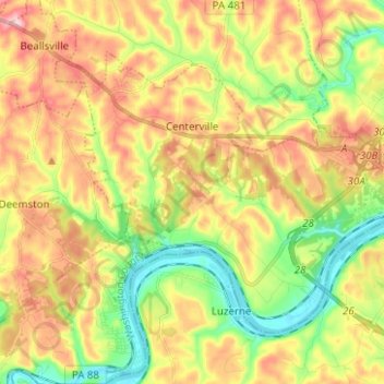
Name: Centerville topographic map, elevation, terrain.
Location: Centerville, Washington County, Pennsylvania, United States (39.99374 -80.02038 40.06394 -79.89554)
Average elevation: 323 m
Minimum elevation: 230 m
Maximum elevation: 428 m
Make a donation
Gear up for your next adventure:
As an Amazon Associate, this site earns from qualifying purchases at no extra cost to you.
Other topographic maps
Click on a map to view its topography, its elevation and its terrain.
Enterprise
United States > Pennsylvania > Washington County > South Strabane Township
Average elevation: 334 m
Hazel Kirk
United States > Pennsylvania > Washington County > Carroll Township
Average elevation: 311 m
Make a donation
Gear up for your next adventure:
As an Amazon Associate, this site earns from qualifying purchases at no extra cost to you.
Vestaburg
United States > Pennsylvania > Washington County > East Bethlehem Township
Average elevation: 308 m
Hickory
United States > Pennsylvania > Washington County > Mount Pleasant Township
Average elevation: 371 m
Fredericktown
United States > Pennsylvania > Washington County > East Bethlehem Township
Average elevation: 306 m
Make a donation
Gear up for your next adventure:
As an Amazon Associate, this site earns from qualifying purchases at no extra cost to you.
Stogletown
United States > Pennsylvania > Washington County > Monongahela > Monongahela
Average elevation: 291 m
Hill Church
United States > Pennsylvania > Washington County > North Strabane Township
Average elevation: 346 m
Make a donation
Gear up for your next adventure:
As an Amazon Associate, this site earns from qualifying purchases at no extra cost to you.
Acheson
United States > Pennsylvania > Washington County > Independence Township
Average elevation: 325 m
Bower Hill
United States > Pennsylvania > Washington County > Peters Township
Average elevation: 348 m
Make a donation
Gear up for your next adventure:
As an Amazon Associate, this site earns from qualifying purchases at no extra cost to you.
Strabane
United States > Pennsylvania > Washington County > North Strabane Township
Average elevation: 329 m
Lake Jo-Ann
United States > Pennsylvania > Washington County > Peters Township
Average elevation: 343 m
Make a donation
Gear up for your next adventure:
As an Amazon Associate, this site earns from qualifying purchases at no extra cost to you.
Eighty Four
United States > Pennsylvania > Washington County > North Strabane Township
Average elevation: 345 m
Prosperity
United States > Pennsylvania > Washington County > Morris Township > Prosperity
Average elevation: 352 m
Buffalo
United States > Pennsylvania > Washington County > Hopewell Township > Buffalo
Average elevation: 370 m
Bulger
United States > Pennsylvania > Washington County > Smith Township > Bulger
Average elevation: 354 m
Make a donation
Gear up for your next adventure:
As an Amazon Associate, this site earns from qualifying purchases at no extra cost to you.
Clover Hill
United States > Pennsylvania > Washington County > West Pike Run Township > Clover Hill
Average elevation: 347 m
Murry Hill
United States > Pennsylvania > Washington County > North Strabane Township
Average elevation: 319 m