
Thank you for supporting this site ❤️
Make a donation
Make a donation
Gear up for your next adventure:
As an Amazon Associate, this site earns from qualifying purchases at no extra cost to you.
Wittenberg topographic map
Click on the map to display elevation.
Thank you for supporting this site ❤️
Make a donation
Make a donation
Gear up for your next adventure:
As an Amazon Associate, this site earns from qualifying purchases at no extra cost to you.
About this map
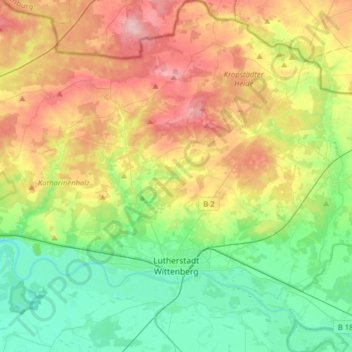
Name: Wittenberg topographic map, elevation, terrain.
Location: Wittenberg, Saxony-Anhalt, Germany (51.81868 12.48492 52.01333 12.77674)
Average elevation: 108 m
Minimum elevation: 55 m
Maximum elevation: 190 m
Thank you for supporting this site ❤️
Make a donation
Make a donation
Gear up for your next adventure:
As an Amazon Associate, this site earns from qualifying purchases at no extra cost to you.
Other topographic maps
Click on a map to view its topography, its elevation and its terrain.
Lutherstadt Wittenberg
Germany > Saxony-Anhalt > Wittenberg > Wittenberg > Lutherstadt Wittenberg
Average elevation: 79 m