
Muttukadu colony topographic map
Interactive map
Click on the map to display elevation.
About this map
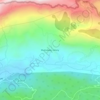
Name: Muttukadu colony topographic map, elevation, terrain.
Location: Muttukadu colony, Udumbanchola, Idukki District, Kerala, India (9.99771 77.12109 10.03771 77.16109)
Average elevation: 1,193 m
Minimum elevation: 912 m
Maximum elevation: 1,774 m
Other topographic maps
Click on a map to view its topography, its elevation and its terrain.
Suryanelli
India > Kerala > Udumbanchola
Suryanelli, Udumbanchola, Idukki District, Kerala, India
Average elevation: 1,553 m
Santhanpara
India > Kerala > Udumbanchola > Choondal
Santhanpara, Choondal, Udumbanchola, Idukki District, Kerala, India
Average elevation: 1,111 m
Poopara
India > Kerala > Udumbanchola
Poopara, Udumbanchola, Idukki District, Kerala, 685619, India
Average elevation: 1,140 m
Murikkumthotti
India > Kerala > Udumbanchola
Murikkumthotti, Udumbanchola, Idukki District, Kerala, 685619, India
Average elevation: 1,099 m
Rajakkad
India > Kerala > Udumbanchola > Kalungu City
Rajakkad, Kalungu City, Udumbanchola, Idukki District, Kerala, 685566, India
Average elevation: 855 m
Rajakumari
India > Kerala > Udumbanchola
Rajakumari, Udumbanchola, Idukki District, Kerala, 685619, India
Average elevation: 1,001 m
7th Mile
India > Kerala > Udumbanchola > Anakkara
7th Mile, Anakkara, Udumbanchola, Idukki District, Kerala, 685509, India
Average elevation: 1,115 m
Thondimala
India > Kerala > Udumbanchola > Poopara
Thondimala, Poopara, Udumbanchola, Idukki District, Kerala, India
Average elevation: 1,390 m
Anakkara
India > Kerala > Udumbanchola
Anakkara, Udumbanchola, Idukki District, Kerala, India
Average elevation: 1,050 m