
Make a donation
Gear up for your next adventure:
As an Amazon Associate, this site earns from qualifying purchases at no extra cost to you.
Charmant topographic map
Click on the map to display elevation.
Make a donation
Gear up for your next adventure:
As an Amazon Associate, this site earns from qualifying purchases at no extra cost to you.
Charmant
Le point culminant de la commune est à une altitude de 203 m, situé au sud-est en limite avec Juillaguet, mais les hauteurs de tout le sud de la commune approximent souvent les 200 m. Le point le plus bas est à 89 m, situé en limite nord au pont des Tempes. Le bourg, construit sur une hauteur adossée sur la cuesta et dominant la vallée est à 140 m d'altitude.
Make a donation
Gear up for your next adventure:
As an Amazon Associate, this site earns from qualifying purchases at no extra cost to you.
About this map
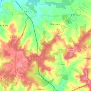
Name: Charmant topographic map, elevation, terrain.
Average elevation: 148 m
Minimum elevation: 88 m
Maximum elevation: 206 m
Make a donation
Gear up for your next adventure:
As an Amazon Associate, this site earns from qualifying purchases at no extra cost to you.
Other topographic maps
Click on a map to view its topography, its elevation and its terrain.