
Make a donation
Gear up for your next adventure:
As an Amazon Associate, this site earns from qualifying purchases at no extra cost to you.
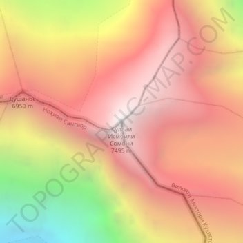
Ismoil Somoni topographic map
Click on the map to display elevation.
Make a donation
Gear up for your next adventure:
As an Amazon Associate, this site earns from qualifying purchases at no extra cost to you.
Ismoil Somoni
In 1928, the long-term Tajik-Pamir expedition of the Academy of Sciences of the USSR began to operate, which began with the Soviet-German expedition with the participation of Willy Rickmers. As a result of topographic survey, it was found that one of the peaks visible in the west of the Fedchenko glaciers reaches a height of 7495 m. Having compared the survey results with a schematic map compiled by Korzhenevsky back in 1925, and with other data, the members of the expedition of the Academy of Sciences decided that this peak is Garmo Peak, which was mapped by the German expedition of 1913 . However, this led to the "mystery of the Garmo", as there was a discrepancy between the heights: 6650 m and 7495 m. This was solved only during the expeditions of 1931 and 1932, when two detachments of climbers and topographers (led by Gorbunov and Krylenko) penetrated the area from the east and from the west. The 6650 m peak was determined to be the real Garmo, and the unnamed 7495 m peak was conclusively discovered and mapped, and given the name Stalin Peak in honor of Stalin's upcoming 55th birthday.
Make a donation
Gear up for your next adventure:
As an Amazon Associate, this site earns from qualifying purchases at no extra cost to you.
About this map
Name: Ismoil Somoni topographic map, elevation, terrain.
Average elevation: 6,554 m
Minimum elevation: 4,936 m
Maximum elevation: 7,509 m
Make a donation
Gear up for your next adventure:
As an Amazon Associate, this site earns from qualifying purchases at no extra cost to you.