
Make a donation
Gear up for your next adventure:
As an Amazon Associate, this site earns from qualifying purchases at no extra cost to you.
Williams topographic map
Click on the map to display elevation.
Make a donation
Gear up for your next adventure:
As an Amazon Associate, this site earns from qualifying purchases at no extra cost to you.
Williams
Bill Williams Mountain rises to an elevation of 9,256 feet (2,821 m) just south of Williams. According to the United States Census Bureau, the city has a total area of 43.8 square miles (113 km2), of which 43.5 square miles (113 km2) is land and 0.3 square miles (0.78 km2), or 0.66%, is water.
Make a donation
Gear up for your next adventure:
As an Amazon Associate, this site earns from qualifying purchases at no extra cost to you.
About this map
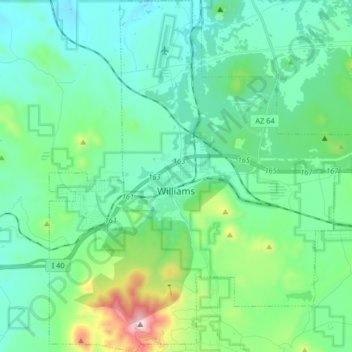
Name: Williams topographic map, elevation, terrain.
Location: Williams, Coconino County, Arizona, 86046, United States (35.18978 -112.24731 35.32272 -112.10644)
Average elevation: 2,131 m
Minimum elevation: 1,962 m
Maximum elevation: 2,811 m
Make a donation
Gear up for your next adventure:
As an Amazon Associate, this site earns from qualifying purchases at no extra cost to you.
Other topographic maps
Click on a map to view its topography, its elevation and its terrain.
Flagstaff
United States > Arizona > Coconino County
Flagstaff is the county seat of Coconino County. According to the United States Census Bureau, the city has a total area of 63.9 square miles (165.5 km2), of which only 0.03 square miles (0.08 km2) (0.08%) is water. Flagstaff lies at approximately 7,000 feet (2,130 m) elevation, and is surrounded by the…
Average elevation: 2,176 m