
Flagstaff topographic map
Click on the map to display elevation.
Flagstaff
Flagstaff is the county seat of Coconino County. According to the United States Census Bureau, the city has a total area of 63.9 square miles (165.5 km2), of which only 0.03 square miles (0.08 km2) (0.08%) is water. Flagstaff lies at approximately 7,000 feet (2,130 m) elevation, and is surrounded by the largest contiguous ponderosa pine forest in North America. It is in a mountainous area, and lies along the Rio de Flag watercourse. It is about 130 miles (210 km) north of the State capital, Phoenix.
About this map
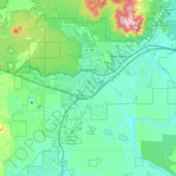
Name: Flagstaff topographic map, elevation, terrain.
Location: Flagstaff, Coconino County, Arizona, United States (35.12240 -111.70894 35.24010 -111.50678)
Average elevation: 2,176 m
Minimum elevation: 2,008 m
Maximum elevation: 2,830 m
Other topographic maps
Click on a map to view its topography, its elevation and its terrain.
Williams
United States > Arizona > Coconino County
Williams occupies a high, forested setting in northern Arizona, in the heart of the Kaibab National Forest at about 6,770 feet (2,063 m) above sea level, where broad plateau surfaces, shallow drainage corridors, and low volcanic hills give the town a gently undulating upland character. Its most prominent…
Average elevation: 2,131 m