
Kunming topographic map
Interactive map
Click on the map to display elevation.
About this map
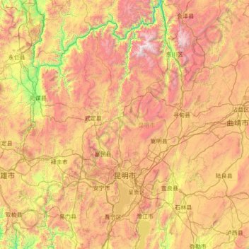
Name: Kunming topographic map, elevation, terrain.
Location: Kunming, Yunnan, China (24.38890 102.16798 26.54849 103.66897)
Average elevation: 1,996 m
Minimum elevation: 714 m
Maximum elevation: 4,184 m
Auffällig sind die recht zahlreichen Solarthermieanlagen auf den Dächern der Wohnhäuser, womit zu 60–70 % der Bedarf an Warmwasser gedeckt wird. Kosten von 2000 RMB pro Anlage stehen Einsparungen bei den Energiekosten in Höhe von 10.000 RMB pro Jahr gegenüber.
Other topographic maps
Click on a map to view its topography, its elevation and its terrain.
Roter Fluss
Roter Fluss, 金平苗族瑶族傣族自治县 (Jinping), 红河州:红河, Yunnan, 661300, China
Average elevation: 1,100 m