
Thank you for supporting this site ❤️
Make a donation
Make a donation
Gear up for your next adventure:
As an Amazon Associate, this site earns from qualifying purchases at no extra cost to you.
伊勢町 topographic map
Click on the map to display elevation.
Thank you for supporting this site ❤️
Make a donation
Make a donation
Gear up for your next adventure:
As an Amazon Associate, this site earns from qualifying purchases at no extra cost to you.
About this map
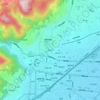
Name: 伊勢町 topographic map, elevation, terrain.
Location: 伊勢町, Nagano, Nagano Prefecture, 380-0851, Japan (36.63850 138.16925 36.67850 138.20925)
Average elevation: 440 m
Minimum elevation: 348 m
Maximum elevation: 818 m
Thank you for supporting this site ❤️
Make a donation
Make a donation
Gear up for your next adventure:
As an Amazon Associate, this site earns from qualifying purchases at no extra cost to you.