
Bridlington topographic map
Interactive map
Click on the map to display elevation.
About this map
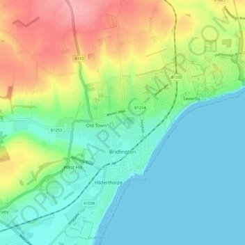
Name: Bridlington topographic map, elevation, terrain.
Location: Bridlington, East Riding of Yorkshire, England, United Kingdom (54.06355 -0.24967 54.12586 -0.14117)
Average elevation: 35 m
Minimum elevation: 0 m
Maximum elevation: 106 m
Other topographic maps
Click on a map to view its topography, its elevation and its terrain.
Hessle
United Kingdom > England > East Riding of Yorkshire
Hessle, East Riding of Yorkshire, England, United Kingdom
Average elevation: 10 m
Willerby
United Kingdom > England > East Riding of Yorkshire
Willerby, East Riding of Yorkshire, England, United Kingdom
Average elevation: 28 m
Thornton
United Kingdom > England > East Riding of Yorkshire
Thornton, East Riding of Yorkshire, England, YO42 4SE, United Kingdom
Average elevation: 10 m
Pentlands
United Kingdom > England > East Riding of Yorkshire > Adlingfleet
Pentlands, Twin Rivers, Adlingfleet, East Riding of Yorkshire, England, DN14 8HY, United Kingdom
Average elevation: 2 m
Beverley
United Kingdom > England > East Riding of Yorkshire
Beverley, East Riding of Yorkshire, England, United Kingdom
Average elevation: 17 m
Lund
United Kingdom > England > East Riding of Yorkshire
Lund, East Riding of Yorkshire, England, United Kingdom
Average elevation: 38 m
Swanland
United Kingdom > England > East Riding of Yorkshire > Swanland
Swanland, East Riding of Yorkshire, Yorkshire and the Humber, England, United Kingdom
Average elevation: 61 m
Newport
United Kingdom > England > East Riding of Yorkshire > Newport
Newport, East Riding of Yorkshire, Yorkshire and the Humber, England, HU15 2QS, United Kingdom
Average elevation: 3 m
Brough
United Kingdom > England > East Riding of Yorkshire > Brough
Brough, East Riding of Yorkshire, Yorkshire and the Humber, England, HU15 1QZ, United Kingdom
Average elevation: 21 m
Flamborough Headlands
United Kingdom > England > East Riding of Yorkshire > Flamborough Headlands
Flamborough Headlands, East Riding of Yorkshire, Yorkshire and the Humber, England, YO15 1AP, United Kingdom
Average elevation: 12 m
Hotham
United Kingdom > England > East Riding of Yorkshire > Hotham
Hotham, East Riding of Yorkshire, Yorkshire and the Humber, England, YO43 4UB, United Kingdom
Average elevation: 31 m