Geolocate

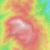
Troodos topographic map

Click on the map to display elevation.

About this map

Name: Troodos topographic map, elevation, terrain.

Location: Troodos, Σύμπλεγμα Κοινοτήτων Τροόδους, Limassol District, Cyprus, 4800, Cyprus (34.90327 32.85882 34.94303 32.90534)

Average elevation: 1,667 m

Minimum elevation: 1,342 m

Maximum elevation: 1,948 m

Other topographic maps

Click on a map to view its topography, its elevation and its terrain.
Gear up for your next adventure:

🧤Thermal Outdoor Gloves - Windproof and waterproof gloves for winter hiking
🍖High-Protein Trail Snacks - Lightweight fuel for long distance treks
🧿Weather Radios - Track weather in remote places
📡Satellite Messengers - Emergency communication for remote areas without signal
📡Satellite Messengers - Emergency messaging when off‑grid

As an Amazon Associate, this site earns from qualifying purchases at no extra cost to you.