
Make a donation
Gear up for your next adventure:
As an Amazon Associate, this site earns from qualifying purchases at no extra cost to you.
Embu topographic map
Click on the map to display elevation.
Make a donation
Gear up for your next adventure:
As an Amazon Associate, this site earns from qualifying purchases at no extra cost to you.
Embu
Embu County slopes from North-West towards East and South-East with a few isolated hills such as Kiambere, Kianjiru and Kiang'ombe which rise above the general height and slope. The county is characterised by highlands and lowlands. It rises from about 515m above sea level at the Tana river basin in the East to over 4,570m above sea in the North West which is part of Mt. Kenya. Embu County is served by six major rivers;for of them, Thũci, Tana, Kiĩ and Rũvingasĩ which form part of the Embu County's boundaries. The other two rivers are Thiba and Ĩna. All these rivers are perennial. Between Embu town and Thũci river lies an area with an altitude ranging from 910m to 1,525m above sea level. The southern part of the county is covered by Mwea plains. It then rises Northwards, culminating in hills and valleys to the Northern and Eastern parts.
Make a donation
Gear up for your next adventure:
As an Amazon Associate, this site earns from qualifying purchases at no extra cost to you.
About this map
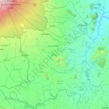
Name: Embu topographic map, elevation, terrain.
Location: Embu, Eastern, Kenya (-0.91816 37.26789 -0.15205 37.93651)
Average elevation: 1,221 m
Minimum elevation: 471 m
Maximum elevation: 5,086 m
Make a donation
Gear up for your next adventure:
As an Amazon Associate, this site earns from qualifying purchases at no extra cost to you.
Other topographic maps
Click on a map to view its topography, its elevation and its terrain.
Nyahururu
Kenya > Laikipia County > Laikipia West
Nyahururu is also frequented by marathon and cross-country runners for practicing before major events due to its high altitude.
Average elevation: 2,348 m
Make a donation
Gear up for your next adventure:
As an Amazon Associate, this site earns from qualifying purchases at no extra cost to you.
Eldoret
Kenya > Uasin Gishu County > Moiben
Eldoret is a city in the Rift Valley region of Kenya. It serves as the capital of Uasin Gishu County. Located in western Kenya, and lying south of the Cherangani Hills, the local elevation varies from about 2,100 metres (6,900 ft) at the airport to more than 2,700 metres (8,900 ft) in nearby areas.
Average elevation: 2,093 m
Make a donation
Gear up for your next adventure:
As an Amazon Associate, this site earns from qualifying purchases at no extra cost to you.
Make a donation
Gear up for your next adventure:
As an Amazon Associate, this site earns from qualifying purchases at no extra cost to you.
Make a donation
Gear up for your next adventure:
As an Amazon Associate, this site earns from qualifying purchases at no extra cost to you.
Make a donation
Gear up for your next adventure:
As an Amazon Associate, this site earns from qualifying purchases at no extra cost to you.
Make a donation
Gear up for your next adventure:
As an Amazon Associate, this site earns from qualifying purchases at no extra cost to you.