
Make a donation
Gear up for your next adventure:
As an Amazon Associate, this site earns from qualifying purchases at no extra cost to you.
Einkorn topographic map
Click on the map to display elevation.
Make a donation
Gear up for your next adventure:
As an Amazon Associate, this site earns from qualifying purchases at no extra cost to you.
Einkorn
Über eine Holztreppe, deren oberste Stufen innerhalb eines an der Nordostecke des Turms angebauten Scharwachtturms verlaufen, gelangt man zur überdachten Aussichtsplattform, die auf rund 25 m Höhe liegt. Von hier hat man einen weiten Blick über die Haller und Hohenloher Ebene und ins Kochertal hinunter. Der Aufstieg führt über 137 Stufen inklusive Türschwelle.
Make a donation
Gear up for your next adventure:
As an Amazon Associate, this site earns from qualifying purchases at no extra cost to you.
About this map
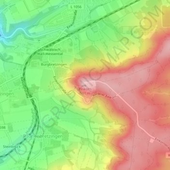
Name: Einkorn topographic map, elevation, terrain.
Average elevation: 412 m
Minimum elevation: 309 m
Maximum elevation: 511 m
Make a donation
Gear up for your next adventure:
As an Amazon Associate, this site earns from qualifying purchases at no extra cost to you.
Other topographic maps
Click on a map to view its topography, its elevation and its terrain.
Gelbingen
Deutschland > Baden-Württemberg > Landkreis Schwäbisch Hall > Schwäbisch Hall
Average elevation: 347 m
Gailenkirchen
Deutschland > Baden-Württemberg > Landkreis Schwäbisch Hall > Schwäbisch Hall
Average elevation: 398 m
Tüngental
Deutschland > Baden-Württemberg > Landkreis Schwäbisch Hall > Schwäbisch Hall
Average elevation: 391 m
74523
Deutschland > Baden-Württemberg > Landkreis Schwäbisch Hall > Schwäbisch Hall > Hessental
Average elevation: 405 m
Make a donation
Gear up for your next adventure:
As an Amazon Associate, this site earns from qualifying purchases at no extra cost to you.
74523
Deutschland > Baden-Württemberg > Landkreis Schwäbisch Hall > Schwäbisch Hall > Hessental
Average elevation: 405 m