
Make a donation
Gear up for your next adventure:
As an Amazon Associate, this site earns from qualifying purchases at no extra cost to you.
Baad topographic map
Click on the map to display elevation.
Make a donation
Gear up for your next adventure:
As an Amazon Associate, this site earns from qualifying purchases at no extra cost to you.
Baad
Baad liegt am Ende des Kleinwalsertals, noch etwa 4 km hinter Mittelberg, auf etwa 1244 m ü. A. Höhe. Der Ort ist ein Ortschaftsbestandteil der Ortschaft Mittelberg, wird aber ortsüblich als eigenständiger Ortsteil gerechnet. Er umfasst, zusammen mit der kleinen Ortslage Vorderboden, etwa 35 Gebäude mit um die 150 Einwohnern.
Make a donation
Gear up for your next adventure:
As an Amazon Associate, this site earns from qualifying purchases at no extra cost to you.
About this map
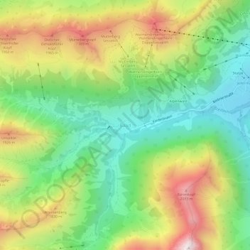
Name: Baad topographic map, elevation, terrain.
Average elevation: 1,558 m
Minimum elevation: 1,141 m
Maximum elevation: 2,176 m
Make a donation
Gear up for your next adventure:
As an Amazon Associate, this site earns from qualifying purchases at no extra cost to you.