
Thank you for supporting this site ❤️
Make a donation
Make a donation
Gear up for your next adventure:
As an Amazon Associate, this site earns from qualifying purchases at no extra cost to you.
Potulando topographic map
Click on the map to display elevation.
Thank you for supporting this site ❤️
Make a donation
Make a donation
Gear up for your next adventure:
As an Amazon Associate, this site earns from qualifying purchases at no extra cost to you.
About this map
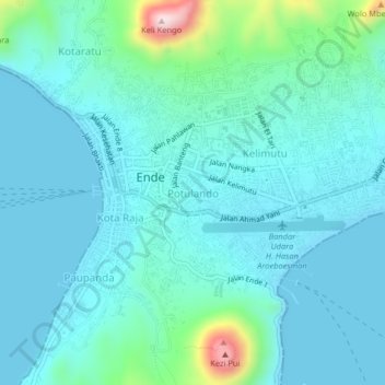
Name: Potulando topographic map, elevation, terrain.
Location: Potulando, Ende, East Nusa Tenggara, 86315, Indonesia (-8.86561 121.63243 -8.82561 121.67243)
Average elevation: 63 m
Minimum elevation: 0 m
Maximum elevation: 421 m
Thank you for supporting this site ❤️
Make a donation
Make a donation
Gear up for your next adventure:
As an Amazon Associate, this site earns from qualifying purchases at no extra cost to you.