
Make a donation
Gear up for your next adventure:
As an Amazon Associate, this site earns from qualifying purchases at no extra cost to you.
Dürwiß topographic map
Click on the map to display elevation.
Make a donation
Gear up for your next adventure:
As an Amazon Associate, this site earns from qualifying purchases at no extra cost to you.
Dürwiß
Dürwiß ist ein nördlicher Stadtteil von Eschweiler in Nordrhein-Westfalen. Die Höhe beträgt im Schnitt 156 m ü. NHN. Nördlich von Dürwiß liegt der Blausteinsee.
Make a donation
Gear up for your next adventure:
As an Amazon Associate, this site earns from qualifying purchases at no extra cost to you.
About this map
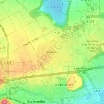
Name: Dürwiß topographic map, elevation, terrain.
Average elevation: 153 m
Minimum elevation: 122 m
Maximum elevation: 190 m
Make a donation
Gear up for your next adventure:
As an Amazon Associate, this site earns from qualifying purchases at no extra cost to you.
Other topographic maps
Click on a map to view its topography, its elevation and its terrain.
Blausteinsee
Deutschland > Nordrhein-Westfalen > Städteregion Aachen > Eschweiler > Fronhoven
Am 5. Oktober 1994 begann die Befüllung des Blausteinsees. Die Wasserfontäne befand sich etwa in Seemitte rund 500 m vom Ufer entfernt und spritzte mit etwa 210 Litern Wasser pro Sekunde 40 m in die Höhe. Jährlich flossen bis zu 6,7 Millionen Kubikmeter Wasser in den See, und für die Erstbefüllung waren…
Average elevation: 143 m
52249
Deutschland > Nordrhein-Westfalen > Städteregion Aachen > Eschweiler > Dürwiß
Average elevation: 161 m