
Thank you for supporting this site ❤️
Make a donation
Make a donation
Gear up for your next adventure:
As an Amazon Associate, this site earns from qualifying purchases at no extra cost to you.
Surmoli topographic map
Click on the map to display elevation.
Thank you for supporting this site ❤️
Make a donation
Make a donation
Gear up for your next adventure:
As an Amazon Associate, this site earns from qualifying purchases at no extra cost to you.
About this map
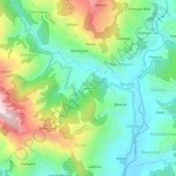
Name: Surmoli topographic map, elevation, terrain.
Location: Surmoli, Deghat, Syalde, Almora, Uttarakhand, 263659, India (29.87963 79.19293 29.91963 79.23293)
Average elevation: 1,154 m
Minimum elevation: 925 m
Maximum elevation: 1,620 m
Thank you for supporting this site ❤️
Make a donation
Make a donation
Gear up for your next adventure:
As an Amazon Associate, this site earns from qualifying purchases at no extra cost to you.