
Make a donation
Gear up for your next adventure:
As an Amazon Associate, this site earns from qualifying purchases at no extra cost to you.
Tatla Lake topographic map
Click on the map to display elevation.
Make a donation
Gear up for your next adventure:
As an Amazon Associate, this site earns from qualifying purchases at no extra cost to you.
About this map
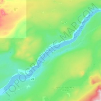
Name: Tatla Lake topographic map, elevation, terrain.
Average elevation: 1,080 m
Minimum elevation: 907 m
Maximum elevation: 1,619 m
Make a donation
Gear up for your next adventure:
As an Amazon Associate, this site earns from qualifying purchases at no extra cost to you.
Other topographic maps
Click on a map to view its topography, its elevation and its terrain.
Mount Juno
Canada > British Columbia > Cariboo Regional District > Area J (West Chilcotin)
Average elevation: 2,219 m
Kondor Lake
Canada > British Columbia > Cariboo Regional District > Area J (West Chilcotin)
Average elevation: 1,718 m
Anahim Lake
Canada > British Columbia > Cariboo Regional District > Area J (West Chilcotin)
Average elevation: 1,101 m
Heckman Pass
Canada > British Columbia > Cariboo Regional District > Area J (West Chilcotin)
Average elevation: 1,519 m
Make a donation
Gear up for your next adventure:
As an Amazon Associate, this site earns from qualifying purchases at no extra cost to you.
Itcha Range
Canada > British Columbia > Cariboo Regional District > Area J (West Chilcotin)
Average elevation: 1,747 m
Ilgachuz Range
Canada > British Columbia > Cariboo Regional District > Area J (West Chilcotin)
The Ilgachuz Range is a name given to an extinct shield volcano in British Columbia, Canada. It is not a mountain range in the normal sense, because it was formed as a single volcano that has been eroded for the past five million years. It lies on the Chilcotin Plateau, located some 350 kilometres (220 mi)…
Average elevation: 2,018 m
Rainbow Range
Canada > British Columbia > Cariboo Regional District > Area J (West Chilcotin)
Average elevation: 1,741 m
Nimpo Lake
Canada > British Columbia > Cariboo Regional District > Area J (West Chilcotin)
Average elevation: 1,131 m
Make a donation
Gear up for your next adventure:
As an Amazon Associate, this site earns from qualifying purchases at no extra cost to you.
Anahim Peak
Canada > British Columbia > Cariboo Regional District > Area J (West Chilcotin)
Average elevation: 1,416 m
Puntzi Mountain
Canada > British Columbia > Cariboo Regional District > Area J (West Chilcotin)
Average elevation: 1,293 m
The Joker
Canada > British Columbia > Cariboo Regional District > Area J (West Chilcotin)
Average elevation: 2,157 m
Great Canyon
Canada > British Columbia > Cariboo Regional District > Area J (West Chilcotin)
Average elevation: 1,220 m
Make a donation
Gear up for your next adventure:
As an Amazon Associate, this site earns from qualifying purchases at no extra cost to you.
Great Canyon
Canada > British Columbia > Cariboo Regional District > Area J (West Chilcotin)
Average elevation: 1,220 m
Map Glacier
Canada > British Columbia > Cariboo Regional District > Area J (West Chilcotin)
Average elevation: 2,037 m