
Make a donation
Gear up for your next adventure:
As an Amazon Associate, this site earns from qualifying purchases at no extra cost to you.
Hazyview topographic map
Click on the map to display elevation.
Make a donation
Gear up for your next adventure:
As an Amazon Associate, this site earns from qualifying purchases at no extra cost to you.
About this map
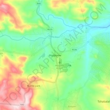
Name: Hazyview topographic map, elevation, terrain.
Average elevation: 554 m
Minimum elevation: 431 m
Maximum elevation: 776 m
Make a donation
Gear up for your next adventure:
As an Amazon Associate, this site earns from qualifying purchases at no extra cost to you.
Other topographic maps
Click on a map to view its topography, its elevation and its terrain.
Kanyamazane
South Africa > Mpumalanga > Ehlanzeni District Municipality > Mbombela
Average elevation: 636 m
Klipkoppie Dam
South Africa > Mpumalanga > Ehlanzeni District Municipality > Mbombela
Average elevation: 973 m
Tekwane North
South Africa > Mpumalanga > Ehlanzeni District Municipality > Mbombela > eMankayana
Average elevation: 771 m
Longmere Dam
South Africa > Mpumalanga > Ehlanzeni District Municipality > Mbombela > White River Country Estates
Average elevation: 963 m
Make a donation
Gear up for your next adventure:
As an Amazon Associate, this site earns from qualifying purchases at no extra cost to you.