
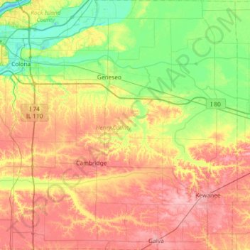
Henry County topographic map
Interactive map
Click on the map to display elevation.
About this map
Name: Henry County topographic map, elevation, terrain.
Location: Henry County, Illinois, United States of America (41.14967 -90.43968 41.58625 -89.85547)
Average elevation: 214 m
Minimum elevation: 170 m
Maximum elevation: 270 m
According to the US Census Bureau, the county has a total area of 826 square miles (2,140 km2), of which 823 square miles (2,130 km2) is land and 2.7 square miles (7.0 km2) (0.3%) is water. It is the 29th largest of Illinois' 102 counties. The area is fairly flat, with elevations ranging from 650 feet above sea level in the northwest to 850 in the southeast. About 456,596 acres (1,847.78 km2) or 86.7% of the county's land area, is used for agriculture.
Other topographic maps
Click on a map to view its topography, its elevation and its terrain.
Champaign County
United States of America > Illinois
Champaign County, Illinois, United States of America
Average elevation: 217 m
Wayne County
United States of America > Illinois
Wayne County, Illinois, United States of America
Average elevation: 133 m
Pike County
United States of America > Illinois
Pike County, Illinois, United States of America
Average elevation: 184 m
Deerfield
United States of America > Illinois > Deerfield
Deerfield, Lake County, Illinois, 60015, United States of America
Average elevation: 204 m
Woodlawn
United States of America > Illinois > Woodlawn
Woodlawn, Jefferson County, Illinois, United States of America
Average elevation: 149 m
Gallatin County
United States of America > Illinois
Gallatin County, Illinois, United States of America
Average elevation: 122 m
White County
United States of America > Illinois
White County, Illinois, United States of America
Average elevation: 122 m
Cook County
United States of America > Illinois
Cook County, Illinois, United States of America
Average elevation: 199 m
Alexander County
United States of America > Illinois
Alexander County, Illinois, United States of America
Average elevation: 112 m
Vergennes
United States of America > Illinois > Vergennes > Vergennes
Vergennes, Jackson County, Illinois, United States of America
Average elevation: 121 m