
Make a donation
Gear up for your next adventure:
As an Amazon Associate, this site earns from qualifying purchases at no extra cost to you.
Lago del Comelico topographic map
Click on the map to display elevation.
Make a donation
Gear up for your next adventure:
As an Amazon Associate, this site earns from qualifying purchases at no extra cost to you.
About this map
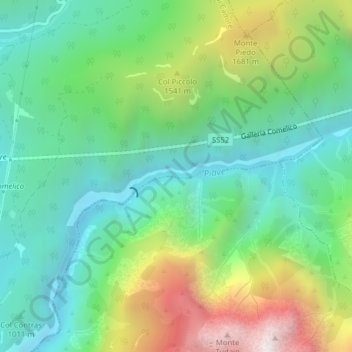
Name: Lago del Comelico topographic map, elevation, terrain.
Average elevation: 1,241 m
Minimum elevation: 787 m
Maximum elevation: 2,223 m
Make a donation
Gear up for your next adventure:
As an Amazon Associate, this site earns from qualifying purchases at no extra cost to you.
Other topographic maps
Click on a map to view its topography, its elevation and its terrain.
Misurinasee
Italien > Venetien > Belluno > Auronzo di Cadore > Misurina
Der Misurinasee (italienisch Lago di Misurina) ist ein See in den Dolomiten in der Provinz Belluno in Venetien, der seinen Namen aus der Siedlung Misurina annimmt. Die maximale Tiefe des Sees beträgt 5 m. Der 1756 m hoch gelegene See ist vom Südwesten von Cortina d’Ampezzo, vom Höhlensteintal im Norden…
Average elevation: 1,904 m