
Make a donation
Gear up for your next adventure:
As an Amazon Associate, this site earns from qualifying purchases at no extra cost to you.
Cassel topographic map
Click on the map to display elevation.
Make a donation
Gear up for your next adventure:
As an Amazon Associate, this site earns from qualifying purchases at no extra cost to you.
Cassel
Cassel is a census-designated place (CDP) in Shasta County, California. Cassel sits at an elevation of 3,176 feet (968 m). Its population is 207 as of the 2020 census, remaining the same from the 2010 census. The ZIP Code is 96016. The community is inside area code 530.
Make a donation
Gear up for your next adventure:
As an Amazon Associate, this site earns from qualifying purchases at no extra cost to you.
About this map
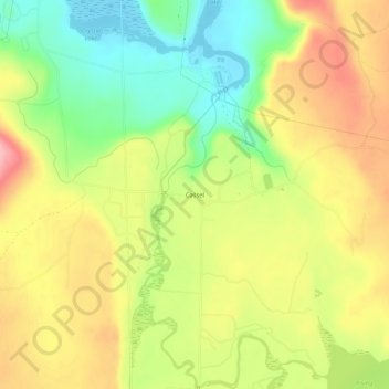
Name: Cassel topographic map, elevation, terrain.
Location: Cassel, Shasta County, California, 96016, United States (40.89905 -121.56776 40.93905 -121.52776)
Average elevation: 972 m
Minimum elevation: 905 m
Maximum elevation: 1,040 m
Make a donation
Gear up for your next adventure:
As an Amazon Associate, this site earns from qualifying purchases at no extra cost to you.
Other topographic maps
Click on a map to view its topography, its elevation and its terrain.
Palo Cedro
United States > California > Shasta County > Palo Cedro
Palo Cedro is located at 40°33′4″N 122°14′3″W / 40.55111°N 122.23417°W / 40.55111; -122.23417 (40.551091, −122.234255) at an elevation of 465 ft (143 m) above sea level.
Average elevation: 157 m
Make a donation
Gear up for your next adventure:
As an Amazon Associate, this site earns from qualifying purchases at no extra cost to you.
Make a donation
Gear up for your next adventure:
As an Amazon Associate, this site earns from qualifying purchases at no extra cost to you.