
Make a donation
Gear up for your next adventure:
As an Amazon Associate, this site earns from qualifying purchases at no extra cost to you.
Rath/Heumar topographic map
Click on the map to display elevation.
Make a donation
Gear up for your next adventure:
As an Amazon Associate, this site earns from qualifying purchases at no extra cost to you.
Rath/Heumar
Rath/Heumar liegt an der östlichen Stadtgrenze und grenzt im Osten an den Waldrand des Naherholungsbereiches Königsforst vor den Höhen des Bergischen Landes und an die Bergische Heideterrasse. Im Osten befinden sich Bergisch Gladbach und Rösrath, im Süden der Ortsteil Eil, im Westen Gremberghoven und Ostheim, im Nordwesten Neubrück und im Norden Brück. Aufgrund der Lage ist Rath/Heumar eine bevorzugte Wohngegend mit mehreren Siedlungen von Einfamilienhäusern.
Make a donation
Gear up for your next adventure:
As an Amazon Associate, this site earns from qualifying purchases at no extra cost to you.
About this map
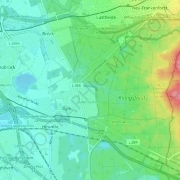
Name: Rath/Heumar topographic map, elevation, terrain.
Location: Rath/Heumar, Kalk, Köln, Nordrhein-Westfalen, 51107, Deutschland (50.91004 7.05848 50.94684 7.14535)
Average elevation: 65 m
Minimum elevation: 41 m
Maximum elevation: 133 m
Make a donation
Gear up for your next adventure:
As an Amazon Associate, this site earns from qualifying purchases at no extra cost to you.
Other topographic maps
Click on a map to view its topography, its elevation and its terrain.
Make a donation
Gear up for your next adventure:
As an Amazon Associate, this site earns from qualifying purchases at no extra cost to you.