
Make a donation
Gear up for your next adventure:
As an Amazon Associate, this site earns from qualifying purchases at no extra cost to you.
Rustenburg topographic map
Click on the map to display elevation.
Make a donation
Gear up for your next adventure:
As an Amazon Associate, this site earns from qualifying purchases at no extra cost to you.
Rustenburg
Rustenburg has a humid subtropical climate (Köppen Cwa), with a relatively high degree of diurnal temperature variation due to the high elevation. It has very warm summers (from December to February) and mild winters (from June to August). Due to the altitude, summers are not quite as hot as one might expect. Precipitation occurs mainly in summer. There is occasional frost at night in winter.
Make a donation
Gear up for your next adventure:
As an Amazon Associate, this site earns from qualifying purchases at no extra cost to you.
About this map
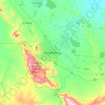
Name: Rustenburg topographic map, elevation, terrain.
Average elevation: 1,217 m
Minimum elevation: 1,028 m
Maximum elevation: 1,756 m
Make a donation
Gear up for your next adventure:
As an Amazon Associate, this site earns from qualifying purchases at no extra cost to you.
Other topographic maps
Click on a map to view its topography, its elevation and its terrain.
Hartbeespoort Dam
South Africa > North West > Bojanala Platinum District Municipality > Madibeng Local Municipality > Kosmos
Average elevation: 1,254 m
Pilanesberg National Park
South Africa > North West > Bojanala Platinum District Municipality
Average elevation: 1,186 m
Madibeng Local Municipality
South Africa > North West > Bojanala Platinum District Municipality
Average elevation: 1,147 m
Pienaars River
South Africa > North West > Bojanala Platinum District Municipality > Madibeng Local Municipality
Average elevation: 1,032 m
Make a donation
Gear up for your next adventure:
As an Amazon Associate, this site earns from qualifying purchases at no extra cost to you.
Moretele Local Municipality
South Africa > North West > Bojanala Platinum District Municipality
Average elevation: 1,057 m
Vaalkop Dam
South Africa > North West > Bojanala Platinum District Municipality > Rustenburg Local Municipality
Average elevation: 987 m
Rooikoppies Dam
South Africa > North West > Bojanala Platinum District Municipality > Madibeng Local Municipality
Average elevation: 1,047 m
Hex River
South Africa > North West > Bojanala Platinum District Municipality > Rustenburg
Average elevation: 1,209 m
Make a donation
Gear up for your next adventure:
As an Amazon Associate, this site earns from qualifying purchases at no extra cost to you.
Moses Kotane Local Municipality
South Africa > North West > Bojanala Platinum District Municipality
Average elevation: 1,084 m
Rustenburg Local Municipality
South Africa > North West > Bojanala Platinum District Municipality
Average elevation: 1,287 m
Ukutula Lodge & Lion Park
South Africa > North West > Bojanala Platinum District Municipality > Madibeng Local Municipality
Average elevation: 1,085 m
Rustenburg Local Municipality
South Africa > North West > Bojanala Platinum District Municipality
Average elevation: 1,287 m
Make a donation
Gear up for your next adventure:
As an Amazon Associate, this site earns from qualifying purchases at no extra cost to you.
Kgaswane Mountain Nature Reserve
South Africa > North West > Bojanala Platinum District Municipality > Rustenburg Local Municipality
Average elevation: 1,307 m
Moretele Local Municipality
South Africa > North West > Bojanala Platinum District Municipality
Average elevation: 1,057 m
Moses Kotane Local Municipality
South Africa > North West > Bojanala Platinum District Municipality
Average elevation: 1,084 m
Madibeng Local Municipality
South Africa > North West > Bojanala Platinum District Municipality
Average elevation: 1,147 m
Make a donation
Gear up for your next adventure:
As an Amazon Associate, this site earns from qualifying purchases at no extra cost to you.
Moretele Local Municipality
South Africa > North West > Bojanala Platinum District Municipality
Average elevation: 1,057 m
Madibeng Local Municipality
South Africa > North West > Bojanala Platinum District Municipality
Average elevation: 1,147 m
Rooikoppies Dam
South Africa > North West > Bojanala Platinum District Municipality > Madibeng Local Municipality
Average elevation: 1,047 m
Kgetleng River Local Municipality
South Africa > North West > Bojanala Platinum District Municipality
Average elevation: 1,367 m
Make a donation
Gear up for your next adventure:
As an Amazon Associate, this site earns from qualifying purchases at no extra cost to you.
Kgetlengrivier Ward 2
South Africa > North West > Bojanala Platinum District Municipality > Kgetleng River Local Municipality
Average elevation: 1,278 m
Valley of Waves
South Africa > North West > Bojanala Platinum District Municipality > Moses Kotane Local Municipality > Sun City
Average elevation: 1,175 m
Madibeng Ward 14
South Africa > North West > Bojanala Platinum District Municipality > Madibeng Local Municipality
Average elevation: 1,067 m
Moses Kotane Local Municipality
South Africa > North West > Bojanala Platinum District Municipality
Average elevation: 1,084 m
Make a donation
Gear up for your next adventure:
As an Amazon Associate, this site earns from qualifying purchases at no extra cost to you.
Moses Kotane Local Municipality
South Africa > North West > Bojanala Platinum District Municipality
Average elevation: 1,084 m