
Make a donation
Gear up for your next adventure:
As an Amazon Associate, this site earns from qualifying purchases at no extra cost to you.
Bella Vista topographic map
Click on the map to display elevation.
Make a donation
Gear up for your next adventure:
As an Amazon Associate, this site earns from qualifying purchases at no extra cost to you.
About this map
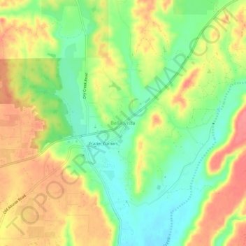
Name: Bella Vista topographic map, elevation, terrain.
Average elevation: 188 m
Minimum elevation: 152 m
Maximum elevation: 224 m
Make a donation
Gear up for your next adventure:
As an Amazon Associate, this site earns from qualifying purchases at no extra cost to you.
Other topographic maps
Click on a map to view its topography, its elevation and its terrain.
Redding
United States > California > Shasta County
The elevation in Redding is 495 feet (151 meters) on average, whereas anywhere to the north, east, or west of downtown ranges between 550 feet (170 m) and 800 feet (240 m) feet. Southern portions range between 400 feet (120 m) and 500 feet (150 m).
Average elevation: 240 m
Redding
United States > California > Shasta County
The elevation in Redding is 495 feet (151 meters) on average, whereas anywhere to the north, east, or west of downtown ranges between 550 feet (170 m) and 800 feet (240 m) feet. Southern portions range between 400 feet (120 m) and 500 feet (150 m).
Average elevation: 241 m
Make a donation
Gear up for your next adventure:
As an Amazon Associate, this site earns from qualifying purchases at no extra cost to you.
Make a donation
Gear up for your next adventure:
As an Amazon Associate, this site earns from qualifying purchases at no extra cost to you.
Whiskeytown-Shasta-Trinity National Recreation Area - Shasta Unit
United States > California > Shasta County
Average elevation: 612 m
Lassen Volcanic National Park
United States > California > Shasta County
According to the Köppen climate classification system, Lassen Volcanic National Park has a Mediterranean-influenced warm-summer Humid continental climate (Dsb). According to the United States Department of Agriculture, the Plant Hardiness zone at Kohm Yah-mah-nee Visitor Center at 6,736 ft (2,053 m) elevation…
Average elevation: 1,972 m
Make a donation
Gear up for your next adventure:
As an Amazon Associate, this site earns from qualifying purchases at no extra cost to you.
Lassen Volcanic National Park
United States > California > Shasta County
According to the Köppen climate classification system, Lassen Volcanic National Park has a Mediterranean-influenced warm-summer Humid continental climate (Dsb). According to the United States Department of Agriculture, the Plant Hardiness zone at Kohm Yah-mah-nee Visitor Center at 6,736 ft (2,053 m) elevation…
Average elevation: 1,972 m
Redding
United States > California > Shasta County
The elevation in Redding is 495 feet (151 meters) on average, whereas anywhere to the north, east, or west of downtown ranges between 550 and 800 feet (170 and 240 m). Southern portions range between 400 and 500 feet (120 and 150 m).
Average elevation: 241 m
Make a donation
Gear up for your next adventure:
As an Amazon Associate, this site earns from qualifying purchases at no extra cost to you.
Make a donation
Gear up for your next adventure:
As an Amazon Associate, this site earns from qualifying purchases at no extra cost to you.
Lassen Volcanic National Park
United States > California > Shasta County
According to the Köppen climate classification system, Lassen Volcanic National Park has a Mediterranean-influenced warm-summer Humid continental climate (Dsb). According to the United States Department of Agriculture, the Plant Hardiness zone at Kohm Yah-mah-nee Visitor Center at 6,736 ft (2,053 m) elevation…
Average elevation: 1,972 m
Palo Cedro
United States > California > Shasta County
Palo Cedro is located at 40°33′4″N 122°14′3″W / 40.55111°N 122.23417°W / 40.55111; -122.23417 (40.551091, −122.234255) at an elevation of 465 ft (143 m) above sea level.
Average elevation: 157 m
Make a donation
Gear up for your next adventure:
As an Amazon Associate, this site earns from qualifying purchases at no extra cost to you.
Palo Cedro
United States > California > Shasta County
Palo Cedro is located at 40°33′4″N 122°14′3″W / 40.55111°N 122.23417°W / 40.55111; -122.23417 (40.551091, −122.234255) at an elevation of 465 ft (143 m) above sea level.
Average elevation: 157 m
Whiskeytown-Shasta-Trinity National Recreation Area - Shasta Unit
United States > California > Shasta County
Average elevation: 612 m