
Thank you for supporting this site ❤️
Make a donation
Make a donation
Gear up for your next adventure:
As an Amazon Associate, this site earns from qualifying purchases at no extra cost to you.
Düns topographic map
Click on the map to display elevation.
Thank you for supporting this site ❤️
Make a donation
Make a donation
Gear up for your next adventure:
As an Amazon Associate, this site earns from qualifying purchases at no extra cost to you.
Düns
Der Name Túnia soll seiner alten Betonung nach vorrömischen Ursprungs sein, unter Umständen eine Ableitung von *Dûnia im Sinne von zur Anhöhe, Burg gehörig und mit dem kelt.: *dûnon im Sinne von Höhe, Burg verwandt sein.
Thank you for supporting this site ❤️
Make a donation
Make a donation
Gear up for your next adventure:
As an Amazon Associate, this site earns from qualifying purchases at no extra cost to you.
About this map
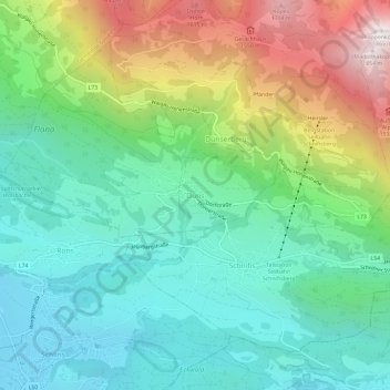
Name: Düns topographic map, elevation, terrain.
Average elevation: 911 m
Minimum elevation: 490 m
Maximum elevation: 1,835 m
Thank you for supporting this site ❤️
Make a donation
Make a donation
Gear up for your next adventure:
As an Amazon Associate, this site earns from qualifying purchases at no extra cost to you.