
Make a donation
Gear up for your next adventure:
As an Amazon Associate, this site earns from qualifying purchases at no extra cost to you.
Vandling topographic map
Click on the map to display elevation.
Make a donation
Gear up for your next adventure:
As an Amazon Associate, this site earns from qualifying purchases at no extra cost to you.
About this map
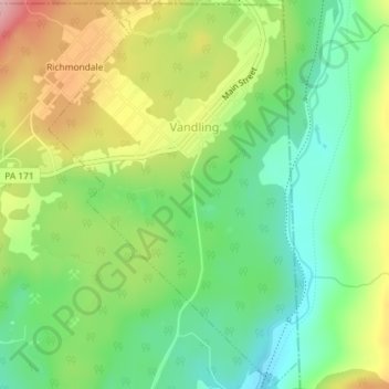
Name: Vandling topographic map, elevation, terrain.
Location: Vandling, Lackawanna County, Pennsylvania, United States (41.61520 -75.48413 41.64170 -75.46073)
Average elevation: 465 m
Minimum elevation: 395 m
Maximum elevation: 570 m
Make a donation
Gear up for your next adventure:
As an Amazon Associate, this site earns from qualifying purchases at no extra cost to you.
Other topographic maps
Click on a map to view its topography, its elevation and its terrain.
Church Hill
United States > Pennsylvania > Lackawanna County > Benton Township
Average elevation: 362 m
Chinchilla
United States > Pennsylvania > Lackawanna County > South Abington Township
Average elevation: 430 m
Moosic Lakes
United States > Pennsylvania > Lackawanna County > Jefferson Township
Average elevation: 615 m
Make a donation
Gear up for your next adventure:
As an Amazon Associate, this site earns from qualifying purchases at no extra cost to you.
Moosic Lakes
United States > Pennsylvania > Lackawanna County > Jefferson Township
Average elevation: 617 m
Crystal Lake
United States > Pennsylvania > Lackawanna County > Clifford Township
Average elevation: 527 m
Make a donation
Gear up for your next adventure:
As an Amazon Associate, this site earns from qualifying purchases at no extra cost to you.
Lake Hide Away
United States > Pennsylvania > Lackawanna County > Moscow > Harmony Hills
Average elevation: 518 m
Madisonville
United States > Pennsylvania > Lackawanna County > Madison Township
Average elevation: 512 m
Make a donation
Gear up for your next adventure:
As an Amazon Associate, this site earns from qualifying purchases at no extra cost to you.
Crestwood
United States > Pennsylvania > Lackawanna County > Roaring Brook Township
Average elevation: 512 m
Mount Cobb
United States > Pennsylvania > Lackawanna County > Jefferson Township
Average elevation: 525 m
Make a donation
Gear up for your next adventure:
As an Amazon Associate, this site earns from qualifying purchases at no extra cost to you.