
Make a donation
Gear up for your next adventure:
As an Amazon Associate, this site earns from qualifying purchases at no extra cost to you.
Florida topographic map
Click on the map to display elevation.
Make a donation
Gear up for your next adventure:
As an Amazon Associate, this site earns from qualifying purchases at no extra cost to you.
Florida
Florida is a town in Berkshire County, Massachusetts, United States. It is part of the Pittsfield, Massachusetts Metropolitan Statistical Area. It is home to the east portal of the Hoosac Tunnel, as well as Whitcomb Summit (elevation 2,172 ft or 662 m), the highest point of the Mohawk Trail. Florida contains the village of Drury. At the 2020 census the town had a total population of 694. Despite the town’s name, Florida is statistically the coldest and snowiest town in Massachusetts.
Make a donation
Gear up for your next adventure:
As an Amazon Associate, this site earns from qualifying purchases at no extra cost to you.
About this map
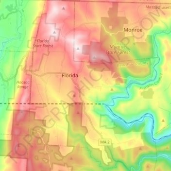
Name: Florida topographic map, elevation, terrain.
Average elevation: 525 m
Minimum elevation: 189 m
Maximum elevation: 859 m
Make a donation
Gear up for your next adventure:
As an Amazon Associate, this site earns from qualifying purchases at no extra cost to you.
Other topographic maps
Click on a map to view its topography, its elevation and its terrain.
Taconic Mountain Wildlife Management Area
United States > Massachusetts > Berkshire County > Williamstown
Average elevation: 608 m
Lake Averic
United States > Massachusetts > Berkshire County > Stockbridge > Interlaken
Average elevation: 326 m
Make a donation
Gear up for your next adventure:
As an Amazon Associate, this site earns from qualifying purchases at no extra cost to you.
Berkshire South
United States > Massachusetts > Berkshire County > Great Barrington
Average elevation: 266 m
Make a donation
Gear up for your next adventure:
As an Amazon Associate, this site earns from qualifying purchases at no extra cost to you.
Root Orchards
United States > Massachusetts > Berkshire County > Great Barrington > Housatonic > Risingdale
Average elevation: 278 m
Natural Bridge State Park
United States > Massachusetts > Berkshire County > North Adams
Average elevation: 318 m
Make a donation
Gear up for your next adventure:
As an Amazon Associate, this site earns from qualifying purchases at no extra cost to you.
West New Boston
United States > Massachusetts > Berkshire County > Sandisfield
Average elevation: 356 m
Make a donation
Gear up for your next adventure:
As an Amazon Associate, this site earns from qualifying purchases at no extra cost to you.
Indian Lake Association
United States > Massachusetts > Berkshire County > Becket
Average elevation: 455 m
Tyringham Cobble
United States > Massachusetts > Berkshire County > Tyringham
Average elevation: 348 m
Beachwood
United States > Massachusetts > Berkshire County > Stockbridge > Beachwood
Average elevation: 317 m
Make a donation
Gear up for your next adventure:
As an Amazon Associate, this site earns from qualifying purchases at no extra cost to you.
North Adams
United States > Massachusetts > Berkshire County > North Adams > North Adams
Average elevation: 415 m
Make a donation
Gear up for your next adventure:
As an Amazon Associate, this site earns from qualifying purchases at no extra cost to you.