
Wilseyville topographic map
Interactive map
Click on the map to display elevation.
About this map
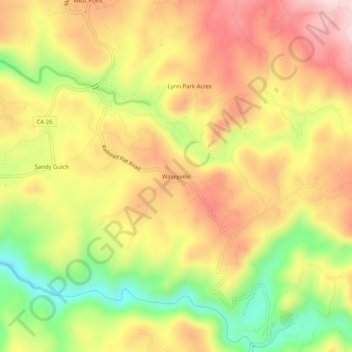
Name: Wilseyville topographic map, elevation, terrain.
Average elevation: 798 m
Minimum elevation: 624 m
Maximum elevation: 940 m
Other topographic maps
Click on a map to view its topography, its elevation and its terrain.
Mokelumne Hill
United States > California > Calaveras County
Mokelumne Hill, Calaveras County, California, United States
Average elevation: 400 m
Rancho Calaveras
United States > California > Calaveras County
Rancho Calaveras, Calaveras County, California, 95252, United States
Average elevation: 168 m
Oak Park Estates
United States > California > Calaveras County > San Andreas
Oak Park Estates, San Andreas, Calaveras County, California, 95249, United States
Average elevation: 355 m
Camp Connell
United States > California > Calaveras County
Camp Connell, Calaveras County, California, United States
Average elevation: 1,542 m
Dorrington
United States > California > Calaveras County
Dorrington, Calaveras County, California, United States
Average elevation: 1,464 m
Copperopolis
United States > California > Calaveras County
Copperopolis, Calaveras County, California, 95228, United States
Average elevation: 304 m
Forest Meadows
United States > California > Calaveras County
Forest Meadows, Calaveras County, California, United States
Average elevation: 886 m
Sheep Ranch
United States > California > Calaveras County
Sheep Ranch, Calaveras County, California, 95250, United States
Average elevation: 719 m
Avery
United States > California > Calaveras County
Avery, Calaveras County, California, 95224, United States
Average elevation: 1,059 m
Campo Seco
United States > California > Calaveras County
Campo Seco, Calaveras County, California, 95226, United States
Average elevation: 185 m
Vallecito
United States > California > Calaveras County
Vallecito, Calaveras County, California, United States
Average elevation: 526 m
Hathaway Pines
United States > California > Calaveras County > Avery
Hathaway Pines, Avery, Calaveras County, California, 95233, United States
Average elevation: 986 m
Glencoe
United States > California > Calaveras County
Glencoe, Calaveras County, California, 95232, United States
Average elevation: 756 m
Paloma
United States > California > Calaveras County
Paloma, Calaveras County, California, United States
Average elevation: 405 m
Arnold
United States > California > Calaveras County
Arnold, Calaveras County, California, 95223, United States
Average elevation: 1,234 m
Wallace
United States > California > Calaveras County
Wallace, Calaveras County, California, 95254, United States
Average elevation: 84 m
Angels Camp
United States > California > Calaveras County
Angels Camp, Calaveras County, California, United States
Average elevation: 461 m
Bummerville
United States > California > Calaveras County
Bummerville, Calaveras County, California, 95255, United States
Average elevation: 876 m
Rail Road Flat
United States > California > Calaveras County
Rail Road Flat, Calaveras County, California, 95248, United States
Average elevation: 831 m
Murphys
United States > California > Calaveras County
Murphys, Calaveras County, California, 95247, United States
Average elevation: 702 m
Arnold
United States > California > Calaveras County
Arnold, Calaveras County, California, United States
Average elevation: 1,171 m
Calaveras Big Trees State Park
United States > California > Calaveras County
Calaveras Big Trees State Park, Calaveras County, California, United States
Average elevation: 1,375 m
Lynn Park Acres
United States > California > Calaveras County
Lynn Park Acres, Calaveras County, California, 95255, United States
Average elevation: 838 m
Sandy Gulch
United States > California > Calaveras County
Sandy Gulch, Calaveras County, California, 95255, United States
Average elevation: 780 m
Fort Mountain
United States > California > Calaveras County
Fort Mountain, Calaveras County, California, 95248, United States
Average elevation: 892 m
Burson
United States > California > Calaveras County
Burson, Calaveras County, California, 95225, United States
Average elevation: 135 m
San Andreas
United States > California > Calaveras County
San Andreas, Calaveras County, California, 95249, United States
Average elevation: 357 m
West Point
United States > California > Calaveras County
West Point, Calaveras County, California, 95255, United States
Average elevation: 794 m
Valley Springs
United States > California > Calaveras County
Valley Springs, Calaveras County, California, United States
Average elevation: 238 m
Felix
United States > California > Calaveras County > Felix
Felix, Calaveras County, California, United States
Average elevation: 349 m
Mountain Ranch
United States > California > Calaveras County
Mountain Ranch, Calaveras County, California, 95246, United States
Average elevation: 733 m
Cave City
United States > California > Calaveras County
Cave City, Calaveras County, California, 95246, United States
Average elevation: 570 m