Geolocate

Mancroft topographic map

Click on the map to display elevation.

About this map

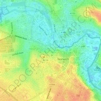
Name: Mancroft topographic map, elevation, terrain.

Location: Mancroft, Norwich, Norfolk, England, United Kingdom (52.62014 1.27322 52.64158 1.30546)

Average elevation: 19 m

Minimum elevation: 0 m

Maximum elevation: 42 m

Other topographic maps

Click on a map to view its topography, its elevation and its terrain.

Norwich

United Kingdom > England > Norfolk > Norwich

Average elevation: 29 m

Earlham Park

United Kingdom > England > Norfolk > Norwich

Average elevation: 22 m

Cringleford Wood

United Kingdom > England > Norfolk > Norwich

Average elevation: 22 m

Gear up for your next adventure:

⛷️Mountain Sports Accessories - Gear for high intensity outdoor sports
🥾Hiking Boots - Top hiking boots for Irish trails and rugged terrain
🔪Multi‑Tools & Knives - Versatile tools for outdoor tasks
🎒Waterproof Backpacks - Protect your gear from rain on Irish hikes
🎽Thermal Base Layers - Essential moisture management for cold weather

As an Amazon Associate, this site earns from qualifying purchases at no extra cost to you.