
Make a donation
Gear up for your next adventure:
As an Amazon Associate, this site earns from qualifying purchases at no extra cost to you.
Coll de Nargó topographic map
Click on the map to display elevation.
Make a donation
Gear up for your next adventure:
As an Amazon Associate, this site earns from qualifying purchases at no extra cost to you.
About this map
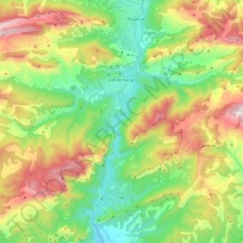
Name: Coll de Nargó topographic map, elevation, terrain.
Location: Coll de Nargó, Alt Urgell, Lleida, Catalonia, 25793, Spain (42.07711 1.15543 42.21970 1.35397)
Average elevation: 954 m
Minimum elevation: 439 m
Maximum elevation: 1,786 m
Make a donation
Gear up for your next adventure:
As an Amazon Associate, this site earns from qualifying purchases at no extra cost to you.
Other topographic maps
Click on a map to view its topography, its elevation and its terrain.
Bony de Serena
Spain > Catalonia > Alt Urgell > les Valls de Valira > Bordes de Jussà
Average elevation: 1,795 m
Make a donation
Gear up for your next adventure:
As an Amazon Associate, this site earns from qualifying purchases at no extra cost to you.