
Make a donation
Gear up for your next adventure:
As an Amazon Associate, this site earns from qualifying purchases at no extra cost to you.
Altenberg bei Linz topographic map
Click on the map to display elevation.
Make a donation
Gear up for your next adventure:
As an Amazon Associate, this site earns from qualifying purchases at no extra cost to you.
Altenberg bei Linz
Located on a southern part of the Zentralmühlviertler Hochland [de] at an altitude of 592 meters, the municipality has a view over the Mühlviertel region, Linz, the capital of Upper Austria as well as the so-called Zentralland and even the foothills of the Northern Limestone Alps. Because of that, it has been described as the "Balcony of Linz".
Make a donation
Gear up for your next adventure:
As an Amazon Associate, this site earns from qualifying purchases at no extra cost to you.
About this map
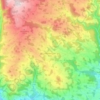
Name: Altenberg bei Linz topographic map, elevation, terrain.
Average elevation: 573 m
Minimum elevation: 317 m
Maximum elevation: 843 m
Make a donation
Gear up for your next adventure:
As an Amazon Associate, this site earns from qualifying purchases at no extra cost to you.
Other topographic maps
Click on a map to view its topography, its elevation and its terrain.