
Thank you for supporting this site ❤️
Make a donation
Make a donation
Gear up for your next adventure:
As an Amazon Associate, this site earns from qualifying purchases at no extra cost to you.
Yvorne topographic map
Click on the map to display elevation.
Thank you for supporting this site ❤️
Make a donation
Make a donation
Gear up for your next adventure:
As an Amazon Associate, this site earns from qualifying purchases at no extra cost to you.
About this map
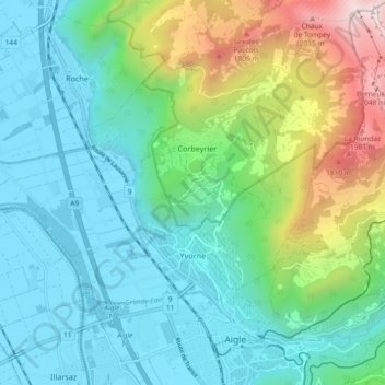
Name: Yvorne topographic map, elevation, terrain.
Location: Yvorne, District d'Aigle, Vaud, 1853, Switzerland (46.32397 6.89585 46.36030 6.98812)
Average elevation: 832 m
Minimum elevation: 371 m
Maximum elevation: 2,258 m
Thank you for supporting this site ❤️
Make a donation
Make a donation
Gear up for your next adventure:
As an Amazon Associate, this site earns from qualifying purchases at no extra cost to you.