
La Esperanza topographic map
Interactive map
Click on the map to display elevation.
About this map
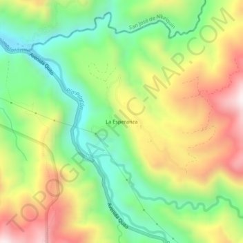
Name: La Esperanza topographic map, elevation, terrain.
Average elevation: 1,477 m
Minimum elevation: 1,143 m
Maximum elevation: 1,919 m
Other topographic maps
Click on a map to view its topography, its elevation and its terrain.
Manuel Cornejo Astorga Tandapi
Equador > Pichincha > Machachi > Manuel Cornejo Astorga (Tandapi)
Manuel Cornejo Astorga Tandapi, Manuel Cornejo Astorga (Tandapi), Machachi, Pichincha, Equador
Average elevation: 1,768 m